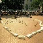
Alan Michelson (1953-, Mohawk) created a type of sculptural reenactment when he installed Earth’s Eye (1990) in lower Manhattan’s Collect Pond Park, outlining the now absent pond, a freshwater source that sustained Manhattan residents until tanneries polluted it and it had to be filled in during 1803. Forty cast concrete markers (22”x14”x6” each) referenced the natural and social history of the pond with low-relief imagery of plants and animals, and were arranged in the outline of the pond. Passersby walked around and within the installation, “bringing previous states of the locale into the here and now.” (Everett, Deborah. “Alan Michelson,” Sculpture, May 2007, Vol. 26 No. 4. Page 31.)
Category Archives: Mapping
Michael Belmore, Coalescence (2017)
“Michael Belmore’s Coalescence was conceived as a single sculpture in four parts, [as part of LandMarks2017/ Repères2017 invites people to creatively explore and deepen their connection to the land through a series of contemporary art projects in and around Canada’s National Parks and Historic Sites from June 10-25, 2017.]. Sixteen stones, ranging in weight from 300 to 1,200 pounds, are fitted together and inlaid with copper, then situated to frame the vast distance between the southernmost boundary of the Laurentide Ice Sheet near Grasslands National Park in Saskatchewan, to one of its points of drainage into Hudson Bay in Churchill, Manitoba.
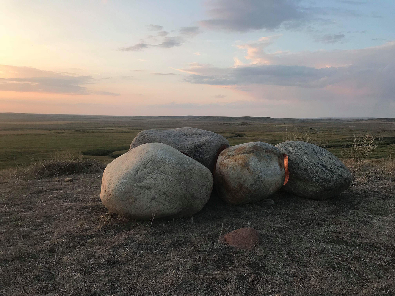
Sites in Riding Mountain National Park and The Forks National Historic Site, both in Manitoba, punctuate the stones’ migration. Together, the four locations mark meeting points between water and land: ancient shorelines, trade routes and meeting places, sites of annual mass migrations of animals, as well as the forced displacement of peoples.
Belmore uses copper as a way to invest the stones with labour and value. The stones come against each other to create a perfect fit, while their concave surfaces move apart slightly to reveal the warm glow of copper to reflect light. Each crevice is filled with a fire that will be extinguished with age, turning brown, then black, and reaching a luminous green hue as it settles into the landscape. They are a marker of how everything comes from the ground and returns to it, and how these processes stretch far beyond human understanding of time.
Belmore has created a moment of connection between deep geological time of stone and the linear human time of labour. On the occasion of the 150th anniversary of Confederation, this connection acts as a reminder of how the timelines of national celebration do not take into account the timelines of the land on which they take place. The stones were going to traverse a land familiar with rising and falling waters to reach their locations, but spring 2017 brought a record snowstorm and a spring melt that washed out the rail line that serves as the main transport artery between Churchill and southern Manitoba.
The political negotiations that followed have left the responsibility for its repair unresolved — part of the continued legacy of colonialism, the challenges of northern transportation and migration, and the importance of international trade routes that go back to Canada’s first trading posts. Belmore’s piece remains intact in Churchill, its splitting and migration halted by the processes that reach out from its conceptual core.” [credit]
Los Carpinteros, Sandalia (2004)
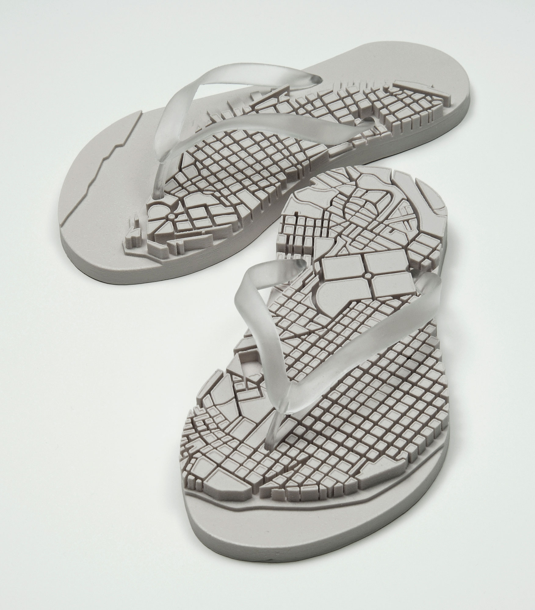
Two cast rubber sculptures
Each sandal: 12-3/4 x 5-3/4 x 2-1/2 inches
Edition: 60
“The sculpture multiple Sandalia is an edition of 60. The object is produced from a rapid prototype model and cast in rubber. By producing a limited edition of rubber sandals with relief maps of Havana neighborhoods on the soles, the artists adapted an ordinary object of mass production into a customized and poeticized icon that speaks of place, identity and culture. Sandalia derives from a series of watercolor drawings of sandals with maps. The right sandal depicts Old Havana, the left Vedado.”
“Over the past decade, Los Carpinteros (Marco Castillo and Dagoberto Rodriguez) have collaborated to develop their own poetic direction that functions in the imprecise boundary between art and craft traditions. Their carefully constructed works use humor to exploit a visual syntax that sets up contradictions among object, function and language.
Los Carpinteros have emerged as a vital force in the new, expanded terrain of global art. They live and work in Havana and Madrid and continue to travel and exhibit globally. For example: a major wall drawing was included in Drawing Now at the Museum of Modern Art-Queens, New York; their Transportable City was exhibited at the 7th Havana Biennial and at PS1 Contemporary Art Center in New York, the Los Angeles County Museum of Art, and the Contemporary Art Museum of Hawaii in Honolulu. In March, 2004 they exhibited a new body of work including drawings and large-scale wood sculptures at Anthony Grant, Inc. in New York City. In 2005 their exhibition Inventing the World premiered at the USF Contemporary Art Museum.”
[credit]
Philippe Guillaume, Every Foot of The Sidewalk: boulevard Saint-Laurent (2010-2012)
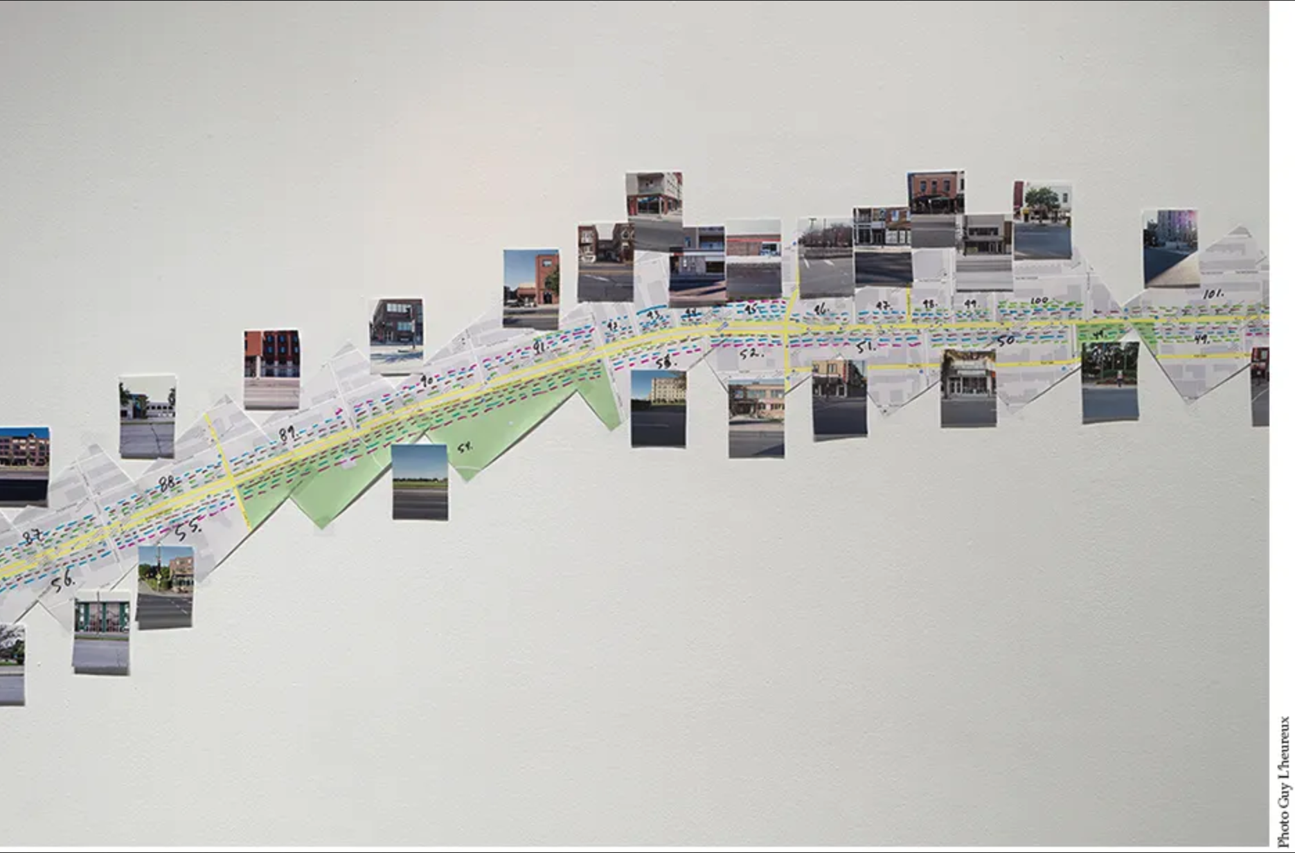
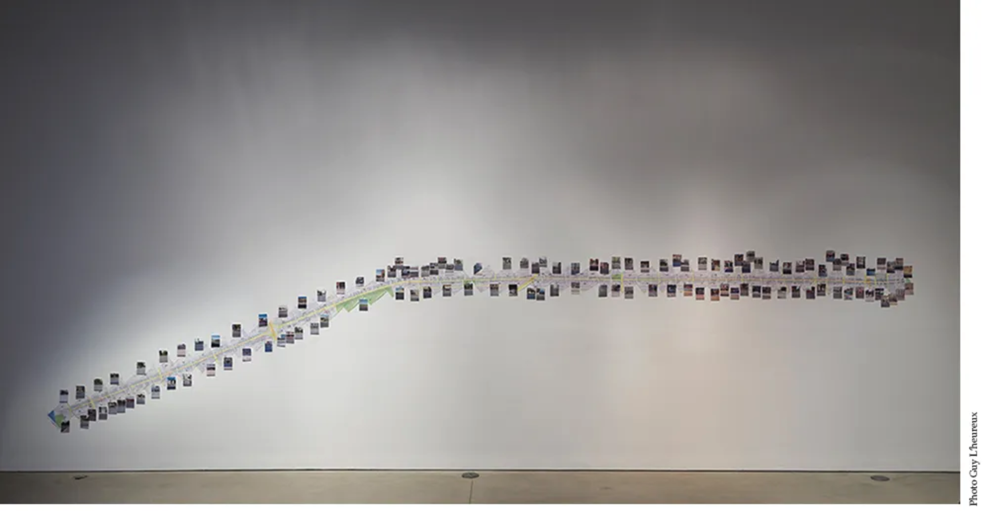
Every Foot Of The Sidewalk: boulevard Saint-Laurent
Map (2010-2012)
original mixed media, google map, photos, pencil, tape
42” x 276”
FOFA Gallery exhibition, Montreal (2013)
[credit]
—
“Philippe Guillaume’s Every Foot of the Sidewalk: boulevard Saint-Laurent (2010-2012) currently exhibited at the FOFA Gallery is a compilation of photographic cityscapes of the desolate Boulevard Saint-Laurent. Upon entering the FOFA’s main gallery, the viewer is immediately immersed in the eerie void created by these rarely captured moments of what is commonly the busy and populated Boulevard Saint-Laurent. One of the works, Working map of Every Foot of the Sidewalk: boulevard Saint-Laurent (2010-2012) displays a linear arrangement of photographs in parallel with a Google map image of the boulevard. The map is numbered, indicating the specific locations in which the photographs were taken. This work invites the viewer to participate by locating him/herself along this frequently visited and familiar street. In depicting this Montreal landmark, the artist is attempting to offer a new or perhaps different perspective of the space and street by removing its principal component of people. Guillaume’s work encompasses the act, art and history of walking and photography in order to explore concepts of space, community and a lack there of.
Among the books and articles left for consultation in the center of the main gallery lies Rebecca Solnit’s Wanderlust: A History of Walking. Solnit seems to have played an influential role in the artist’s process and discussion of this work. The void captured in the photographs brings attention to a conversation common in Solnit’s work, regarding streets, people and shared spaces. Streets, such as boulevard Saint-Laurent, act as a space of congregation, a space for festivals, parades, revolutions and protests. They act as a place for voicing and displaying one’s citizenship, a shared and “unsegregated zone.”[1]Particularly in light of the student protests last year in Montreal, Guillaume’s city of no citizens explores an interesting juxtaposition between the possible usages of space that touches on many social, political and spatial discussions relevant today. — Review written by Caro Loutfi.
David Taylor, Working the Line (2007)
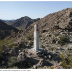
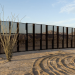

“Beginning in 2007, started photographing along the U.S.-Mexico border between El Paso/Juarez and San Diego/Tijuana. My project is organized around an effort to document all of the monuments that mark the international boundary west of the Rio Grande. The rigorous undertaking to reach all of the 276 obelisks, most of which were installed between the years 1891 and 1895, has inevitably led to encounters with migrants, smugglers, the Border Patrol, minutemen and residents of the borderlands.
During the period of my work the United States Border Patrol has doubled in size and the federal government has constructed over 600 miles of pedestrian fencing and vehicle barrier. With apparatus that range from simple tire drags (that erase foot prints allowing fresh evidence of crossing to be more readily identified) to seismic sensors (that detect the passage of people on foot or in a vehicle) the border is under constant surveillance. To date the Border Patrol has attained “operational control” in many areas, however people and drugs continue to cross. Much of that traffic occurs in the most remote, rugged areas of the southwest deserts.
My travels along the border have been done both alone and in the company of agents. In total, the resulting pictures are intended to offer a view into locations and situations that we generally do not access and portray a highly complex physical, social and political topography during a period of dramatic change.” [credit]
On Kawara, I Got Up / I Met / I Went, 1968-79
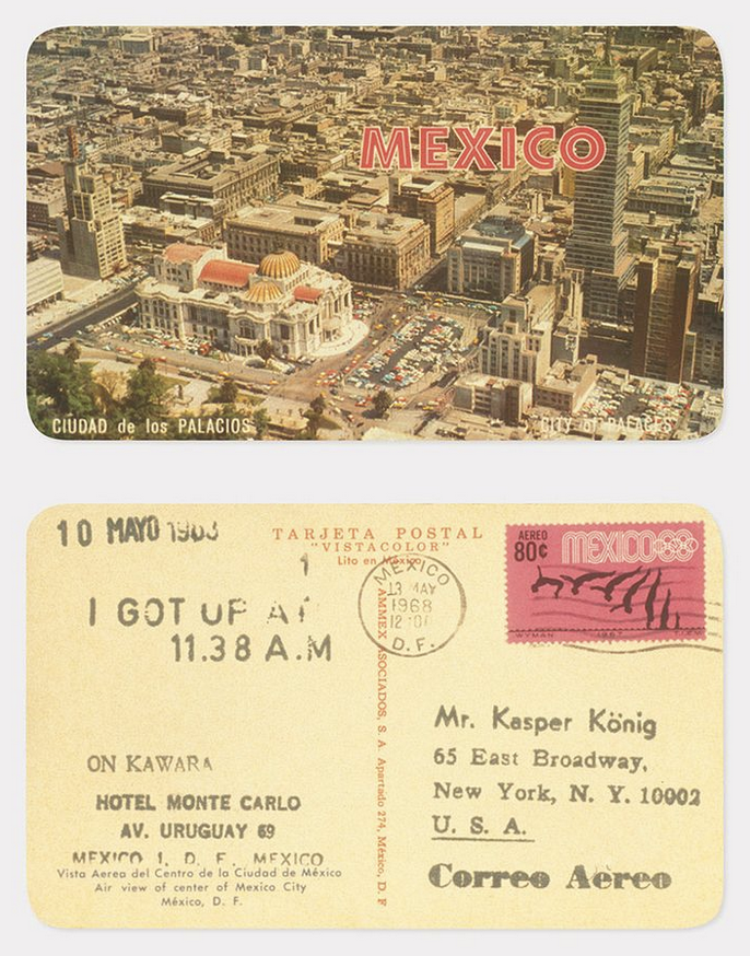
On Kawara (Japanese, 1933–2014)
Photomechanical prints, 8.3 x 14.0 cm (3 1/4 x 5 1/2 in. ) each
Credit Line: Purchase, The Horace W. Goldsmith Foundation Gift, through Joyce and Robert Menschel, 2001
“In the I Got Up series, Kawara sent two postcards every day to friends, family, collectors, colleagues. The postcards that Kawara chose were always horizontal in format, and always of the touristic variety. He played games with the cards, sometimes sending a single recipient multiple[s] of the same image, or taking recipients on tours around the cities.

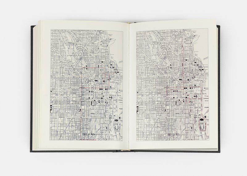
Narrator: Here on Rotunda Level 3, you will see three bodies of work organized by On Kawara to be viewed as a single section of the exhibition that he titled Self-Observation. These works all represent a record of ordinary activities—the kinds of things we all do, each day. Every day for 12 years beginning in 1968, Kawara sent postcards for the series I Got Up, recorded lists of names for I Met, and traced his movements on maps in I Went.
Presented here are over 1,500 of the more than 8,000 postcards comprising I Got Up. Kawara used various kinds of stamping tools to date and address the cards, including a return address, which provides another way to plot his whereabouts. Along with this information he stamped the phrase I GOT UP AT followed by the precise time he arose from bed. Assistant curator Anne Wheeler:
Anne Wheeler: In the I Got Up series, Kawara sent two postcards every day to friends, family, collectors, colleagues. The postcards that Kawara chose were always horizontal in format, and always of the touristic variety. He played games with the cards, sometimes sending a single recipient multiple of the same image, or taking recipients on tours around the cities.
Narrator: Curator Jeffrey Weiss:
Jeffrey Weiss: He’s taking advantage of mediums that already exist in the world. What he’s doing is supposed to reflect the parameters of daily life that are decidedly nonaesthetic. Kawara’s work seems to be the residue, in a way, of a practice of these activities. It takes the form of the repetition of modular elements, or units, that are roughly but not quite the same from one to the next.” [credit]
—
“Considered the most personal and intimate of his works, I GOT UP is part of a continuous piece produced by On Kawara between 1968 and 1979 in which each day the artist sent two different friends or colleagues a picture postcard, each stamped with the exact time he arose that day and the addresses of both sender and recipient. The length of each correspondence ranged from a single card to hundreds sent consecutively over a period of months; the gesture’s repetitive nature is counterbalanced by the artist’s peripatetic global wanderings and exceedingly irregular hours (in 1973 alone he sent postcards from twenty-eight cities). Moreover, Kawara’s postcards do not record his waking up but his “getting up,” with its ambiguous conflation of carnal and existential (as opposed to not getting up) implications.
Contrasted with the random temporal shifts conveyed in the text messages are the diverse images of Manhattan featured on the postcard fronts, which accumulate over the piece’s forty-seven day duration into an unexpectedly quasi-cinematic aerial tour of the city-circling around the United Nations (and inside the General Assembly), down the East River along the waterfront to New York Harbor and the Statue of Liberty, and finally roaming around Federal Plaza at street level before coming to rest at City Hall. Like the newspaper pages that line the special cases housing each date painting, these found images juxtapose the infinite variety and quotidian reality of the public world with the elliptical, self-reflexive messages on the back. The sequence also extracts a drifting urban poetry from the mass-produced and anonymous, layering it conceptually over the banal, functional postal route of the objects themselves, as well as reintroducing a formal design to a work that is at first glance anticompositional.
With tremendous economy of means and a surprising visual elegance, Kawara creates a complex meditation on time, existence, and the relationship between art and life.” [credit]
Kate McLean, Smellfie Kit (2015)
A smellwalking guide. The smellscape is the smell equivalent of a visual landscape.
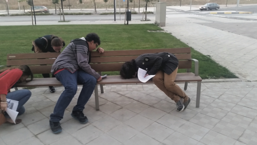
This activity crafted by Kate McLean identifies 3 categories of smells:
- curious / unexpected smells are the short-lived, individually noted smells of the city e.g. books/paper, perfume on a passer-by, metal, paint, marshmallow, old books
- episodic smells reveal specific areas of town, these are localized smells e.g. wet fish, flowers, fried food, medicine
- background smells form a context, these are seen as a constant e.g. canal dampness, humidity and spicy cooking aromas against which all other smells reside
And identifies 3 modes of smelling:
- Smell catching (passive smelling)
- Smell hunting (active smelling)
- Free smelling (a combo of the two)
The activity walks participants through various descriptive reflective writing prompts. It provides a helpful chart for organizing observations and collecting data. It provides options for solo, pair, and group outings. Available via McLean’s website.
Troy Towns
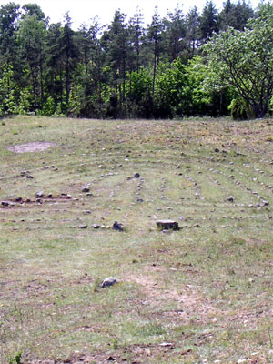
The Troy Town Majbacken lies at Petarve (municipality of Garda) on the island of Gotland, and is approximately 150 years old. This classical labyrinth is stretched a little bit in the height and in the width. It looks somewhat angular.
“The Scandinavian Troy Towns are very old classical labyrinths in the shape of stones laid out in free field. In Germany we have still 4 historic labyrinths (Graitschen, Steigra, Hannover, Kaufbeuren), in England there are 8.
There are about 300 historic, passable stone labyrinths in Sweden, and therefore most of them worldwide. Maybe they are amongst the first in history that could be walked. It is difficulty to say something sure about their age and meaning. Some are probably more than 2000 years old, many 500 years, and some only 100 years. But nevertheless all of them are older as the new labyrinths built worldwide in the last 20 to 30 years. So we may look at the Scandinavian countries as the home of the labyrinth.
In the following you will see the Swedish labyrinths with the eyes of a surveyor and civil engineer. I am interested, where exactly the labyrinths are situated (by GPS), how they are looking like nowadays, which is the pattern and geometric design behind them. Maybe one could call it the search for the ideal line.
Then I think about how to make one with simple measurement methods. Probably they have been built this way. All you need should be some pegs, a ruler, and a rope.”

Troy Town Majbacken in Petarve
[credit]
Predominantly Scandinavian “Troy Towns” are labyrinths with a comparable design, but were built by arranging stones on the surface of open fields. The name references the Troy Game, “A solemn ritual performed at irregular intervals by the ancient Romans to signalize their alleged descent from the Trojans: notable for the interweaving labyrinthine maneuvers executed by youths on horseback,” although scholars cannot confirm the true meaning of these sites, some of which date back 2500 years.
Ella Parry-Davies, Home Maker Soundwalks (2018-)
A collection of soundwalks made with Filipina domestic and care workers employed “behind closed doors” in the Lebanon and the UK. Check out the soundwalks.
Heath Bunting and Kayle Brandon, BorderXing (2002)
“BorderXing, a 2002 commission for the Tate Gallery in London, in which Mr. Bunting, 37, and Ms. Brandon, 28, documented illegal treks they made across European borders.
“I’ve always wanted to be nomadic — to beg, borrow, find things,” Mr. Bunting said. He travels light, often with no change of clothes and only a few basics: a penknife, a diary, a passport.
The BorderXing Web site, available for individual use by request (at irational.org/cgi-bin/border/clients/ deny.pl) offers pictures, suggested routes and tips for evading the authorities. A vacation slide show of the couple’s journey is on view at the New Museum, as well as online, without registration, at duo.irational.org/borderxing–slide–show.
Despite the political provocation involved, the project retains the aura of a pilgrimage — to be close to the land, to throw off the weight of nationality and statehood, simply to put one foot in front of the other and go.
… BorderXing is concerned with the physical, visceral aspects of travel…” [credit] [full article as PDF]