Category Archives: Mapping

Heath Bunting and Kayle Brandon, D’Fence Cuts (2001)

“Heath Bunting emerged from the 1980s art scene committed to building open, democratic communications systems and social contexts. Throughout his career, he has explored multiple media including graffiti and performance art and has staged numerous interventionist projects, as well as being a pioneer in the field of Internet Art. Bunting began collaborating with artist Kyle Brandon in 2001.” [credit]

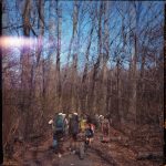
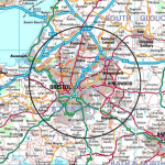
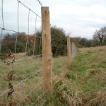
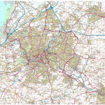
These artists devised a circular tour (see map), and by night stealthily cut some fences as part of their Borderxing project. BorderXing serves as a pratical guide to crossing major international borders, legally or illegally. It was a type of physical hacking of space, cutting anything that impeded their walk – D’Fence Cuts. Below is an excerpt from their tour de fence catalog:

“tour de fence is the answer to your real needs. while the internet promised to level out all barriers, tour de fence enables you to surmount the fences out there that people erect to obstruct your way every day. from wire netting to ru­ stic fence, from steel door to close security system, tour de fence offers you the necessary know-how for unhampered movement. tour de fence is the direct way.

learn offroad mobility within high security architecture. cross over stretches of land in the right direction. penetrate the underground area of your city. tour de fence puts an end to the relocation of your movements into virtual space. use the tour de fence! become a tour de fence amateur team. pass this handbook on to others. propagate tour de fence.

by doing so you will become part of the international tour de fence community. as a reader, a free-climber or by sending one of the 24 tour de fence postcard in this book.

participate now! tour de fence’s vision is to do what we want.

tour de fence acknowledges fence as metaphor for private property. fence as a supposedly temporary, often mobile barrier performing functions of inclusion and exclusion, entrapment and guided freedom, decoration, safety, user boun­ dary, protection from hazard, flow control, visual screening and user separation.

fence is a permeable filter system defining permitted use and users. light, wind, insects, water, plants and sound pass unhindered while high order life forms such as·humans, fish, cattle and cars are engaged:

development of fence.

up to now the vertical has generally been private while the horizontal public. increasingly, vertical fences are being rotated to the horizontal and enlarged over large areas of land, as all use and users are embraced in total control.

tour de fence recognises the transformation of framed freedom into restricted open-range roaming; the re-alignment of unknown possibilities into known re­ peatables. users are permitted to skate across flattened surface of fence, but not to pass through – the fence is everywhere.” (credit)

Walk & Squawk, The Walking Project (2003-2006)

photos of a performance project

Walk and Squawk, The Walking Project (2003-2006)

“The Drawing Project began in Detroit in 1999 and became an interdisciplinary performance, mapping and cultural-exchange project collaboratively developed by Walk & Squawk (Hilary Ramsden and Erika Block), with U.S. and South Africa-based artists and communities during a series of residencies in Detroit and KwaZulu-Natal from 2003 through 2006. Inspired by desire lines people made across vacant lots in Detroit and across fields in South Africa we explored the paths we walk and how they are formed through culture, geography, language, economics and love. We looked at how changing our patterns of movement can alter our attitudes and perception, how taking a different path can alter our lives. We discovered how learning language alters the actual paths in our brains and how taking a car means something very different from taking a walk.” [credit]

Glowlab, One Block Radius (2004)

screenshot of a blog

Glowlab, One Block Radius (2004)

“Beginning in January 2004, artists Christina Ray and Dave Mandi-known as Glowlab – have been examining the block on which our new building will rise (Bowery to Chrystie Street and from Stanton Street to Rivington Street). Glowlab’s project, One Block Radius…provides an in-depth focus on this specific microcosm of New York City. This feature-rich urban record will include personal perspectives from diverse sources such as city workers, children, street performers and architectural historian. Engaging a variety of tools and media such as blogs, video documentation, field recordings and interviews, Glowlab will create a multi-layered portrait of the block as it has never been seen before.” [credit]

“One Block Radius, a project of Brooklyn artists Christina Ray and Dave Mandl [known collaboratively as Glowlab], is an extensive psychogeographic survey of the block where New York’s New Museum of Contemporary Art will build a new facility in late 2004. Engaging a variety of tools and media such as blogs, video documentation, maps, field recordings & interviews, Glowlab creates a multi-layered portrait of the block as it has never been seen before [and will never be seen again]. This website is an interactive archive for the project, which will continue to grow over time as we build a dense data-map of the block. The information collected is organized into three categories: observation, interaction & response. Click on each category to begin exploring the block.” [credit]

“While the block is bit-size in relation to the surrounding metropolis, the changes it is about to undergo are massive. One Block Radius plays with this idea of scale, aiming to zoom in and physically data-mine the tiny area for the amount of information one would normally find in a guide book for an entire city. This feature-rich urban record will include personal perspectives from diverse sources such as city workers, children, street performers, artists and architectural historians. ” [credit]


Barbara Lounder, Stamp Sticks (2007)

“During a 2007 Walking and Art residency at the Banff Centre, I made walking sticks and related devices, exploring ways in which walking leaves traces and tracks in the landscape. Walking in the Banff area brings a certain frisson; there is always the possibility of dangerous encounters with other species, the elements, and difficult terrain.” [credit]

Dillon de Give, The Coyote Walks (2009-2017)

“An annual walking project that illustrates a connection between New York City and the wild. It was originally performed to commemorate the spirit of “Hal”, a coyote who appeared in Central Park in 2006 and died shortly after being captured and re-released in the forest. The walk begins in the city and remains within sight of a coyote-like path for three days before ending in a relatively wild area. The Coyote Walk has run as an itinerancy, or walking residency since 2014.” [credit]

“It is collaborative research, a retreat (in an almost literal sense), or a mindful holiday. Prospective fellow walkers may share an interest in related subjects, such as urban planning, folk/visual/movement/social arts, biology or other natural sciences. Participants must be prepared for a strenuous walk (approx. 15 miles per day) and for sleeping outside. Please note, differently abled walkers are encouraged to be in touch.” [credit]

Additional images and writing www.coyotewalks.wordpress.com

“I grew up in the Southwest US (Santa Fe, NM— where coyotes are ever-present both as biological entities and as cultural signifiers). I witnessed this event in the media while living in New York City, and continued to think about it in the years following. I began to feel that a larger narrative was looming behind the topical debates. The incident threw the relationship of the city dweller and the natural world into relief.  It wasnʼt an abstract suggestion of interconnection between the two; it was a (momentary) unmediated instance of collision– a moment of confusion for both. Hal disrupted a normal state of affairs by presenting himself as an embodiment of something external to our picture of daily life in an orderly civilization. In this he was as comedic as he was threatening. Was this a typical animal or an exceptional one? What was he thinking? And how, exactly, did he find his way into the city?

One way to try to understand this story was to guess about the geography of the journey.  The most obvious geographic challenge is the channel of water that separates the island of Manhattan from the mainland of the Bronx– like a moat surrounding a castle. Adrian Benepe, the NYC Parks Commissioner at the time, publicly hypothesized that Hal crossed a small Amtrack trestle bridge over the Spuyten Duyvil Creek at the northern tip of the Manhattan. This became a prevailing theory, but not the only possible one. Other scenarios were equally possible. For example, if Hal had utilized the long Bronx River corridor as a path, he might have crossed over the Harlem River further south and east. Because there were few eyewitness accounts, no camera traps, and no DNA analysis done on Hal, the definite crossing location will remain unknown. This crossing is a big plot point of the story as presented in the media. It came to stand for the dramatic moment in which a cunning trickster privately transgressed from the natural world into the human world. Looking closely at possible routes however, it becomes clear that there were many such crossings.

The Coyote Walks are fueled by curiosity about what it would mean to cross over the line between “the city” and “nature” oneself, to literally connect the two places. The walks are guesses about how coyotes enter New York City that are made with reverse human journeys out of the city. The project began as a kind of memorial to the incident— walked around the anniversary of Hal’s death and initially called the “laH” journey, a backwards spelling of the name. The Coyote Walk is now a time to pose questions about urban life and nature, to learn from the experience of stepping away from the city, and to consider walking practices (human and animal) as imaginative acts.” [credit]

Artist writing:

  • Unpacking (after) a coyote walk. Walking Lab residency, 2017. Link.

  • Connective filaments, coyote walks on the map. Living Maps Review No. 2, 2017.
    Link / Download PDF

  • Tracking the call of the wild from the heart of Manhattan. NYNJ Trailwalker Summer 2012. Download PDF

Speaking:

  • Artists and the Post Industrial Urban Wilderness, Union Docs, 2017. Link

  • Chance Ecologies Symposium, Queens Museum, 2016. Link

  • Re-inscribing the City: Unitary Urbanism Today, Anarchist Book Fair, 2011. Link

Referenced:

  • Urban Coyotes Spur Walks on the wild side. CUNY NYCity News Service. Audio piece by Samia Bouzid

  • “‘Uurga shig’ – What is it like to be a lasso?” Hermione Spriggs, Journal of Material Culture, 2016. Link

  • Out Walking the Dog blog, Melissa Cooper 2011-12. Link

  • City Reliquary event write up in Matt Levy’s Action Direction blog, 2009. Link

Amanda Heng, I Walk from the South to the North (2017)

This work saw Heng travelling alone on foot from Clifford Pier to the Causeway checkpoint in Woodlands. This solo walk continued Amanda’s interest in rituals, exchanges and their relationship with live performance in daily life.

“Heng has been a central figure in Singaporean performance art as well as feminist discourse in Singapore since the 1980s.

In 2017, Heng performed “I Walk From The South To The North” which constitutes a series of daily walks spanning the duration of two months (September – November). … From my perspective, this work is a comment on the breakneck speed at which Singapore develops. Bridges, skyscrapers and entire parks are built in the span of a few months. The urban landscape morphs and mutates unforgivingly. How do people hold on to memory and history?

It also reads to me as a reflection on technology and how we wield it in our contemporary lives to ‘make lives easier’. Singapore is a technologically advanced country with a highly comprehensive transport system. What is the point of walking anywhere anymore? Smartphones are ubiquitous, Google Maps is the most sensible mode of navigation. What is the point of talking to anyone, asking for directions anymore? Heng’s work brings focus back to the physical and social nature of the body and sheds light on the effects which technology has on that.

Could you tell us a bit more about your most recent walk from Clifford Pier to the Causeway which you took from September to November 2017?

It is titled “I Walk from the South to the North”. The participation is a little different from my previous walks. I deliberately do not get myself acquainted with the route so I start to ask around for directions so where I go depends entirely on who I chance upon and how forthcoming they are. I’d get these people to draw out maps or write out directions and these form part of the documentation for this project. Many people I approached were generous with their help and were surprised I wanted to walk so far. They kept insisting it was much faster to take the MRT nearby.” [credit]


Angela Ellsworth and Steven J. Yazzie, Museum of Walking (2014-)

[credit]

The Museum of Walking (MoW) is an artist led educational resource center committed to the advancement of walking as an art practice. MoW is an educational resource committed to people, land, action, and site through the everyday act of walking. Walking is a defining human activity with poetic and political resonance as well as mundane and ceremonial manifestations that play a central role in contemporary art, social and cultural history, health, and sustainable lifestyles. Whether alone or with a group, moving through space creates connections between people and the environment, as it promotes well-being and enhances creative divergent thinking.

MoW houses a small-but-mighty archive and library comprised of walking related material engaging disciplines of art, science, philosophy, health, activism, contemplation and cartography. Through workshops, exhibitions, experiences, and site-specific projects MoW fosters relationships between people, land, action, and place.

The Museum of Walking was founded in 2014 in 120 square foot space. As an itinerant museum we now reside in numerous places. “

Eve Mosher, Walking the Edge (2020)

map of NYC waterfront

[credit]

“Walking the Edge invites New Yorkers to reconnect to the diversity of the city’s shorelines and have a voice in the city planning process. Walking the Edge uses walking to encounter, reflect upon, and see places anew. Walking the Edge is a collaboration between arts organizations Culture Push and Works on Water with the NYC Department of City Planning. Due to Covid-19, we transitioned to online platforms for this project. See walkingtheedge.nyc for more information.”

Lisa Myers, and from then on we lived on blueberries for about a week (2013)


Lisa Myers, ‘and from then on we lived on blueberries for about a week’, made for MAP Spring 2013, 6’44” (animation with assistance from animator Rafaela Kino). This work pays homage to an on-foot journey her grandfather undertook to flee Shingwauk Residential School in Ontario. Myers herself once did an 11-day walk tracing the route of her grandfather’s journey.

“When he was a boy, artist Lisa Myers’s Anishinaabe grandfather walked some 250 kilometres along Northern Ontario railroad tracks for one reason: to escape Shingwauk Residential School in Sault Ste. Marie.

Myers recorded her grandfather’s account of this journey during a conversation with him in the 1990s—and she listened it to it many times before she made the decision, in 2009, to walk the route he’d described alongside her cousin Shelley Essaunce and her nephew Gabriel.

Myers and the Essaunces took 11 days to walk the 250-kilometre journey.

“After this walk,” Myers writes in a 2016 Walter Phillips Gallery exhibition essay titled “Rails and Ties,” “I began thinking about how to locate myself within my grandfather’s story, and about how I wanted to convey its different iterations. One thing that struck me was that he survived by eating blueberries growing along the tracks. He said, ‘and from then on we lived on blueberries for about a week.’”

The latter quotation from her grandfather became the title for a video installation by Myers—one related to trauma, food, walking and survival—that was on view at Artcite in Windsor this spring as part of the exhibition “Walks of Survivance.”

“Instead of always repeating his story, [walking] was a way of finding myself in that story,” Myers told curator Maya Wilson-Sanchez a few years ago. And by walking, Myers also told Wilson-Sanchez, she was “able to bring the places in the story to life.”

“When I recall walking across the railway bridge over the Mississauga River north of Lake Huron,” Myers writes in “Rails and Ties,” “I think about my fear of the elevation, and how gusts of wind unsteadied my steps. Finding my footing meant looking down and seeing the river rushing 50 feet below the railway ties of that century-old steel bridge. The Mississagi River flows into Lake Huron, the railway crosses the river, and from my grandfather’s account of his journey this was the first place (after leaving school) where he heard his language and saw Anishinaabe people cooking and sharing food down by the river. They welcomed him, and fed him.”

During her walk in her grandfather’s footsteps, Myers also heard stories of other youth who had escaped the way he had. Ultimately, her works on this theme—which include both abstract and map-like prints made with blueberry pigments, as well as documentation of wooden spoons stained with blueberries she has shared with others, also speak to a complex intertwining of group and individual journeys, of landscapes that are real and imagined.

“The spoons represent sharing, sustenance and the gathering of people,” Myers writes. “When I line these spoons up side by side, the reddish-blue marks continue from one utensil to the next, recalling an imaginary topography or horizon line created by the trace of berry consumption.”

In this sense, walking and artmaking become different ways of tracing and “straining” an experience.

“Straining to survive, or even to be accepted, means the less digestible parts of stories need to be retained, traced, remembered and told,” Myers writes.

Of course, Myers is not alone in thinking about walking as a mode of Indigenous resistance and survival.

“There’s the water walk that is happening, and which is not directly art-related,” Myers said in a phone interview. “But I think Indigenous artists are wanting to also acknowledge that these forms of activism are happening. There was walking from a community in Nunavut, [Idle No More] walking to Ottawa to make a point.”

“Walking to safety is a really important narrative in talking about survival, and surpassing survival to freedom,” says “Walks of Survivance” curator Srimoyee Mitra.” [credit]


Lisa Myers, ‘Blueberry Spoons’, 2010, video, 7’37”

Benjamin Patterson, Man Who Runs (1963)

This work was presented as a map of the midtown New York Public Library, with arrows showing the route to run, from the main entrance up to the third floor and out again.

Critic Lori Waxman compares this score to Robert Filliou’s One-Minute Scenario (1963), and points out how race and place deeply affect these scores. Filliou is a white French Protestant with a glass eye referencing a hotel, while Patterson is a Black man and references the library.


Credit: Waxman, Lori. Keep Walking Intently: The Ambulatory Art of the Surrealists, the Situationist International, and Fluxus. Sternberg Press, 2017. Page 232.