Category Archives: Mapping

Hock E Aye Vi Edgar Heap of Birds, Most Serene Republics (2007)

Hock E Aye VI Edgar Heap of Birds, (Cheyenne/Arapaho, 1954-)

This work was a temporary memorial for Native Americans who died in Italy as part of Buffalo Bill Cody’s Wild West Show in the late nineteenth century, and was installed at the Venice Biennale in 2007. It consisted of a series of 16 outdoor signs to remember and honor their loss, 8 outdoor signs that serve as commentary, several signs in the water-taxis encouraging repatriation of the Native people’s bodies from Europe to the U.S., as well as a large billboard at the Venice airport that stated ‘welcome to the spectacle, welcome to the show’ as a faux welcoming sign, which was visible as people walked through the airport check point. These Lakota warriors were formerly imprisoned in the U.S. and were given the choice to remain in prison, or go perform in Europe, which was not much of a choice.

Hui-min Tsen, The Pedway (2009-13)

brochure

published 2013 by Green Lantern Press | Specs: 18 pages, 4.2 x 0.2 x 9 inches

“Deep beneath the surface of the city, a tangled ribbon of corridors runs throughout 40 blocks of downtown Chicago. This meandering passage appears to have grown up organically as if it were an animal’s burrow or a donkey’s path.  Its route is illogical: the corridors exist outside of known space, and its hidden entrances lead to mysterious destinations. What is this place?  It is the Chicago Pedway, an intricate non-system of pedestrian tunnels built to separate the citizens of the city from the dangers and foul weather encountered on the street.

On the Trail of a Disorderly Future was an interdisciplinary project consisting of a walking tour of Chicago’s Pedway, ephemera given and sold to tour participants as souvenirs, and a book for a “self-guided” tour of the Chicago Pedway. The project told a story across 36 points-of-interest, weaving together mythic and historical tales to tell the story of urban development, utopian impulses, and fears of the city from the Renaissance until now.

Details: Active from 2009-2013 | performance (90-minute walking tour), ephemera (postcards, map, website), book” (credit)

Catherine D’Ignazio, It takes 154,000 breaths to evacuate Boston (2007-9)

(credit)

“Catherine D’Ignazio ran the entire evacuation route system in Boston and attempted to measure the distance in human breath. The project also involves a podcast and a sculptural installation of the archive of tens of thousands of breaths .

The project is an attempt to measure our post-9/11 collective fear in the individual breaths that it takes to traverse these new geographies of insecurity.

The $827,500 Boston emergency evacuation system was installed in 2006 to demonstrate the city’s preparedness for evacuating people in snowstorms, hurricanes, infrastructure failures, fires and/or terrorist attacks.

It takes 154,000 breaths to evacuate Boston consists of:

  1. a series of running performances in public space (2007)
  2. a web podcast of breaths (2007)
  3. a sculptural installation of the archive of breaths (2008)

Website & Podcast

Project Website: www.evacuateboston.com

Archive of Breaths (sculptural piece)

Medium: custom-made table, 26 jars, 26 speaker components, wire, 13 CD players
Dimensions: 45″x72″x16″

I created a sculptural & audio archive of the collection of breaths. There are 26 jars on a custom-made table which correspond to the 26 runs it took to cover the evacuation routes. Each jar size corresponds to the number of breaths from that run. The speaker inside the jar plays the breaths collected from that run. (Better documentation coming soon)

This piece is on view in Experimental Geography, a traveling show curated by Nato Thompson and produced by ICI.

Sarah Rodigari, Strategies for Leaving and Arriving Home (2011)

person walking next to road

Sarah Rodigari, Strategies for Leaving and Arriving Home (2011); Photography: Adeo Esplago; Presented: Performance Space Sydney, Monash University Museum of Art, Melbourne and Artspace, Sydney
 as part of Art as Verb.

“Walking is a type of process-based research which informs my performance practice. I use walking alongside other social modalities such as conversation to document relational knowledge and to consider how place is historically determined, invented and retold.” (Catalog, “From Here to There: Australian Art and Walking)

“A six-week performative walk in which I relocated 880 kilometres from Melbourne to Sydney in the winter of 2011. I On my back I carried a tent, a sleeping bag and a four-day supply of food. As no ‘official’ walking route exists between these two cities, I mapped out my own path, choosing to follow the train line as best I could. When this was not possible, I followed the Hume Highway. I walked approximately twenty kilometres per day. I had no support vehicle; instead, I invited people to be my support by walking with me or joining me via the project blog.

In addition to documentation presented through essays, maps and the blog, I have included images of people who participated in the project by either walking, offering accommodation, food,a lift, or passing conversation and local knowledge. The inter-personal affective relations experienced in this exchange expose a vulnerability found within the embodied image of this walk: a woman walking alone along a highway. In turn, this mediation changed the process of the walk and thus shaped the nature of the project.” (credit)

Paul-Henry Chombart de Lauwe, Trajets pendant un an d’une jeune fille du XVIe arrondissement (1957)

map with many paths

Situationists’ maps combined objective with subjective. This idiosyncratic map is based on the movements of a single individual studying at the school of political science. A triangle emerges — the vertices are the residence, the university and the home of a piano teacher.

Robin Hewlet and Ben Kinsley, Street With a View (2008)

Google street view photos

Hewlett and Kinsley invited the Google Inc. Street View team and residents of Pittsburgh’s Northside to collaborate on a series of tableaux along Sampsonia Way.

Technicians captured 360-degree photographs of the scenes in action and integrated the images into Street View.

Richard Long, A Walk of Four Hours and Four Circles (1972)

Medium: Presstype on cut-and-pasted paper on printed map with pencil
Dimensions: 9 1/2 × 12 5/8″ (24.1 × 32.1 cm)

Consists of a map with said concentric circles indicated, along with the title. Writer Rebecca Solnit observes, “On the maps the route of the walk is drawn in to suggest that the walking is drawing on a grand scale, that his walking is to the land itself as his pen is to the map, and he often walks straight lines, circles, squares, spirals.” – Wanderlust: A History of Walking. Penguin Books, 2000. Page 270.

Walter De Maria, Las Vegas Piece (1969)

Walter De Maria (1935-2013)

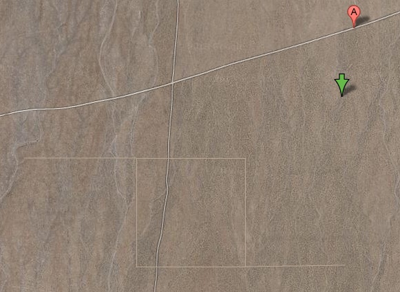
“A large, simple etching on the earth, made with four shallow cuts from the six foot blade of bulldozer, two one mile long, two a half mile long, forming a square with half mile lines extending from it. Made in 1969 by the artist Walter de Maria, in a remote location north of Las Vegas, the piece was not maintained, and is only faintly visible today, to some.” [credit]

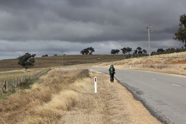
“The question is not whether you can visit Walter De Maria’s Leaving Las Vegas; the question is, does it still exist?
Already in 1972 when discussing the land art project with Paul Cummings, Walter de Maria seemed to emphasize the difficulty of actually experiencing Las Vegas Piece as part of the actual experience of Las Vegas Piece. He’d graded a mile-long square onto a barren desert valley north of the city, and you’d have little chance of even finding it, much less seeing it, much less seeing it all:

it takes you about 2 or 3 hours to drive out to the valley and there is nothing in this valley except a cattle corral somewhere in the back of the valley. Then it takes you 20 minutes to walk off the road to get to the sculpture, so some people have missed it, have lost it. Then, when you hit this sculpture which is a mile long line cut with a bulldozer, at that point you have a choice of walking either east or west. If you walk east you hit a dead end; if you walk west you hit another road, at another point, you hit another line and you actually have a choice.

And on and on for several hours, until your choices and backtracking end in some combination of experiencing the entire sculpture on the ground; declaring victory or defeat partway through; and dying of exposure in the desert because you can’t find your car.” [credit]

Dennis Oppenheim, Ground Mutations – Shoe Prints (1969)

Ground Mutations – Shoe Prints, November 1969, printed 2013

Black-and-white and color photographs and text on two panels

“Shoes with 1/4” diagonal grooves down the soles and heels were worn for three winter months. I was connecting the patterns of thousands of individuals… my thoughts were filled with marching diagrams.”

Saleh Khannah, In Between Camps (2012)

A more recent walking artwork highlighting the intersection of walking and race is In Between Camps (2012), which consisted of a group of six researchers and artists, Ismael Al-bis, Fabio Franz, Matteo Guidi, Thayer Hastings, Ibrahim Jawabreh, Saleh Khannah, Sara Pelligrini, Giuliana Racco, and Diego Segatto, walking across the West Bank from the springs of al-Arroub to Solomon’s Pools (three massive stone reservoirs) south of Bethlehem in search of an ancient Roman waterway, the Arrub Aqueduct. The project originated from the Campus in Camps program developed by Al-Quds University, an experimental education program in the Palestinian refugee camp of al-Dheisheh. The purpose of the project was to both reactivate the water system’s source, and imagine a time-frame before the contemporary apartheid-reality of walls, colonial land parceling, and occupation of Palestine. While they were hiking, the group was stopped by Israeli soldiers who were suspicious of the Palestinian participants due to their skin tone and dress. The international participants intervened and explained the trip, their search of the aqueduct, and showed them the map, engaging in a type of information overload tactic, not unlike the tactics Codogan described for minimizing the perception of criminality. After the walk, the group created a booklet (Booklet ) reflecting on the history of the site, their experience, and how the various layers of race-based rule and exclusion are projected on the land.

Hastings, Thayer. “Tracing a Line Through a Fractured Palestine, from al-Arroub to Bethlehem,” Walking Art / Walking Aesthetics. Accessed May 16, 2022: https://walkingart.interartive.org/2018/12/thayer-palestine