Category Archives: Mapping

Máiréad and Tim Robinson, Folding Landscapes (1972-)

a map

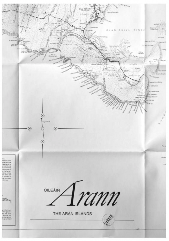
Tim Robinson “Oilerin Arann a map of the aran islands Co. Galway eire” (1996)

“Tim Robinson [1935-2020] is the alter ego of artist Timothy Drever whose abstract paintings and environmental installations were seen in a number of exhibitions in London before he moved to the west of Ireland in 1972. Robinson originally studied mathematics at Cambridge and worked as a teacher and artist in Istanbul, Vienna and London.

He and his wife, Máiréad [1934-2020], [then lived] in Roundstone in Connemara, where, in 1984, they established Folding Landscapes, a specialist publishing house and information resource center dealing with three areas of particular interest around Galway Bay: the Aran Islands, the Burren and Connemara. The maps and accompanying books are beautifully drawn and meticulously researched, explaining, often for the first time, the derivation and meaning of hundreds of place names and representing a wide range of information about the region’s culture and landscapes.

[They] gained much of this information literally on the ground, walking with naturalists, historians, archaeologists and other specialist through the landscape. [Their] maps and books provide an invaluable guide for visitors to the region as well as nourishing community spirit by identifying the irreplaceable uniqueness of the local environment and history. Tim and Mairead also run Unfolding Ideas, an annual Colloquium Series for scholars, educators and artists to engage in public talks, small group discussion and workshops in Roundstone, Connemara.”

Anne Teresa De Keersmaeker, Violin Phase from Fase: Four movements to the Music of Steve Reich (1982)

woman dancing in sand

Anne Teresa De Keersmaeker

“MoMA’s Performance Exhibition Series presents a program of live performance and dance in conjunction with the group exhibition On Line: Drawing Through the Twentieth Century. The dancing body has long been a subject matter for drawing, as seen in a variety of works included in this exhibition. These documentations show dance in two dimensions, allowing it to be seen in a gallery setting. But if one considers line as the trace of a point in motion—an idea at the core of this project—the very act of dance becomes a drawing, an insertion of line into time and the three-dimensional space of our lived world.

Choreography and dance: Anne Teresa De Keersmaeker
Music: Steve Reich, “Violin Phase” (1967)
Violin: Shem Guibbory
Duration: 16 minutes
Created at the Dance Department of New York University’s Tisch School of the Arts, first performed in April 1981 at the Festival of Early Modern Dance, Purchase, New York.
Rosas is the dance ensemble and production structure built around the choreographer and dancer Anne Teresa De Keersmaeker. Find out more at www.rosas.be.” [credit]

Francisca Benítez, “Property Lines, New York” (2008)

[credit]

76 floor rubbings
made on the sidewalks of New York
18″ x 24″, graphite on paper, 2008
Edition of 3

There are seventy rubbings in the series and they were installed as a grid on the wall, with varying dimensions depending on the location. The simple act of tracing in this set of walking-based drawings asks questions about borders, public versus private space, and how people mark space.

Francisca Benitez (b. 1974, Chile) lives and works in New York. Recent solo exhibitions include Cuchifritos Gallery + Project Space, New York (2014); Museo de Artes Visuales, Santiago, Chile (2013); Die Ecke, Santiago, Chile (2011); and Nada.Lokal, Vienna, Austria (2009). Notable group exhibitions include Mapping Brooklyn, Brooklyn Historical Society and BRIC House, Brooklyn (2015); Efemérides, Museo Histórico Nacional, Santiago, Chile (2014); Pier 54, High Line Art, New York (2014); One Minute Film Festival 2003 – 2012, MASS MoCA, North Adams, Massachusetts (2013); The Street Files, El Museo del Barrio, New York (2011); and Contaminaciones Contemporáneas, Museu de Arte Contemporánea da USP, Sao Paulo, Brazil (2010). Her work has been featured in major international exhibitions including the Bienal de la Habana, Cuba (2015); Lisbon Architecture Triennale, Portugal (2013) the Beijing Biennale, China (2009); and the LA Frewaves 10th biennial of film, video and new media, Los Angeles (2006).” (credit)

Brendan Stuart Burns, Ache (2011), and Artist’s Journal

Brendan Stuart Burns, Artist’s Journal

[credit]

“Brendan Stuart Burns’s paintings, drawings and photographs are a direct and physical response to both his walks and his more contemplative moments experienced along particular stretches of the Pembrokeshire coast which he has come to know intimately. Time spent walking, often over the same stretches of the same beaches in all weathers and states of the tide, provides him with the experiences necessary to touch and connect physically and emotionally with the land, its history and deep sense of time, all elements that are ever present in his paintings.

His works present simultaneously a ‘direct’ and ‘sensed’ experience of the landscape, its geology and geomorphology, in addition to the complex psychological effects such places have on the individual. Horizons shift and scale becomes relative as both close-up details and wider perspectives are referenced, often within the same pieces of work, and recreated later in the studio from copious notes and sketch books. Fundamental to Burns’s method is his layered use of oil and wax, building and constructing an equivalent to the experience of surface, form and space.

Each work accordingly sits on the edge between abstraction and representation, reflecting the uneasy balance between the physical and the psychological, intention and accident, the intuitive and the considered. They recreate the entirety of Burns’s experience for us (the transformation of daily and annual cycles; changing climatic and tidal conditions), rather than merely documenting a discrete moment within the traditional confines of naturalism.”


Larsen Husby, Long Trace of Minneapolis (2016-18)

//longtraceofminneapolis.com/

Turkeys crossing Stinson Blvd

Larsen Husby “Turkeys crossing Stinson Blvd”

Watch video footage via MN Originals

“On October 3rd, 2016, I [Larsen Husby] decided to walk every street in Minneapolis. The parameters of this undertaking were as follows:

  • I must walk the entire length of every street within the city limits of Minneapolis, with the exception of streets which do not allow pedestrians, such as interstates and private streets.
  • Every walk must start with the intention of being a walk for the sake of the project; intention may not be applied retroactively.
  • I must record the route, length, and duration of every walk; however, failure to record one aspect of a walk does not disqualify it from counting towards the ultimate goal.

Following these rules, I walked 1,315 miles, finishing on June 26th, 2018.

The title, Long Trace of Minneapolis, addresses two crucial aspects of the work. ‘Trace’ refers to the piece as an act of drawing: my feet are a pencil, drawing invisible lines across the city. If one could see them, these lines would add up to form a trace of the entire street network, a map of Minneapolis the size of Minneapolis. ‘Long’ describes the temporal nature of the piece, which is a lived experience, not an object.  Those invisible lines are drawn not only along the ground, but through minutes, hours, and days.

This website is a document of the piece. It contains records of the project in the form of maps, photographs, measurements, and written reflections.”

Sarah Cullen “The City as Written by the City” 2005-2007

squiggly drawing

The City as Written by the City, Nov 2 2007, Walk to see Trudi and her new pin, Banff Centre – Banff Hospital

abstract drawing

The City as Written by the City, Out and about Florence with Muma, May 21, 2005

[credit]

“Sarah Cullen’s recent works have resulted from collaborative activities with geographers and other artists. In the past, she has created alternative methods of mapping space using low-tech machines and devices of her own invention.

Cullen has, for example, created a ‘drawing box’ consisting of a pencil pendulum that is able to record her movement in space in equivalent strokes of graphite on paper when carried around on a walk. The resulting drawings are almost anti-maps, in the sense that they cannot offer objectivity or legibility. Instead, her artworks bear indexical traces of her presence and motion.

What we lose in immediacy, we gain something in a sense of the weight and measure of movement – of the particular gait and pace of an individual’s walking style. Each of us moves through space with a highly particular and identifiable walk: it is a marker of the way we have learnt to occupy the world. Cullen asks us to re-imagine how we can document the ways in which we have ‘become ourselves’, in motion rather than at rest.”

Photos from constructing the boxes and doing workshops

Chris Drury, 2D works, 2003

a painting

“Ladakh III & IV” (2003), woven maps of Ladakh, pushed into a bowl and set within an area of watercolor paper, 60cm x 60cm


a painting

“High Desert Wind” (2003) a map of the Leh area of Ladakh, digitally printed over a diagram of the cross-section through the apex of the heart, made from rusted iron filings on wet paper (map, rust iron filings, paper) 104×138 cm

[credit]

“Chris Drury is perhaps best known for three­ dimensional works that include installations and sculpture made from natural materials, whether outdoors or in the gallery. Drury is a key figure in what has been called ‘land art’, though his work goes far beyond this term: it has involved collaborations with scientists and experts from a range of disciplines. Drury asserts that ordinarily his work is ‘political’ in that it is able to “draw attention to the way we abuse our environments”. However, another equally important preoccupation is his exploration of what inner or outer nature mean, and the inextricable connections between the two.

‘High Desert Winds’ shows an inkjet map of a walk in the Leh area of Ladak printed over a pattern from a cross section of the human heart made from rust iron filings. The patterns resemble the shape of winds from satellite weather maps. In his woven maps, Drury often weaves two very different or opposite places together uniting them into one. The earth pigments used in the works are always brought back from the actual place and used as dry pigment on wet ground. The most important aspect of walking for Drury is ‘the sense of place’ and the work is always what responds best to the place at that specific moment in time.”

Tim Knowles “From Windwalk – Seven Walks from Seven Dials” 2009

multimedia installation: helmet, sail, wall drawing and monitor

[credit]

“Tim Knowles creates photographs, films and abstract drawings by undertaking walks. Knowles’s working methods are deliberately improbable, idiosyncratic and inventive. He makes use of chance in innumerable ways, ensuring that the outcome of each walk is unknown in advance. As the critic Jessica Lack has written in The Guardian, 11 June 2009, his works are “generated by apparatus, mechanisms, systems and processes beyond the artist’s control”. They are “akin to scientific experimentation, where a situation is engineered in which the outcome is unpredictable. There is a poetry, English eccentricity and wit to the work”.

For ‘Walk On’ Tim Knowles presents an excerpt of a larger work, showing one of a series of seven walks made from Seven Dials, London. Each of these walks is guided solely by the wind as Knowles steadfastly follows a windvane mounted on a helmet worn on his head. He has no ability to affect the windvane and simply acts as a servant to the system he has devised. The wind takes him on a meandering route, at times blown directly down a street, at others caught in eddies repeatedly circling on street corners or joining the city’s other debris down some cul de sac. His meandering path collides with the rigid structure of the city; his route tracing out buildings, railings, ventilation shafts, parked vehicles and other boundaries. Knowles devises a new method of exploring the city and reveals how the wind moves through and is shaped by its structure.”

plan b “All GPS traces in Berlin in 2011-2012” 2012

a map

plan b

two people tracing

plan b

[credit]

plan b is the name that Sophia New and Daniel Belasco Rogers take when working collaboratively as artists. They are amongst the leading figures to engage with GPS technologies since their widespread availability over the last decade or more. Their practice is based on both walking and on data collection including, most notably, their GPS traces. Rogers has tracked every single one of his journeys for a whole decade. New has done the same since 2007. On several occasions they have exhibited an entire year’s worth of traces in one space, effectively making every action they take become public knowledge.

Such actions present ethical problems for us, as much as for the artists. The viewer becomes privy to the artist’s habits and, hence, inner life. If information about apparently innocuous activity such as walking through one’s own city can be timed, monitored and recorded by an artist, such information can easily be known by technology providers and sold to others. Those who might want to observe, redirect, restrict or control our behaviour have new ways of doing so. Most recently, plan b have engraved a whole year’s worth of GPS data onto a transparent acrylic sheet. The journeys that they routinely or repeatedly undertake are ‘dug’ out of the material in an almost archaeological manner. Their habits and ways of inhabiting the city are simultaneously made both monumental and as ghost-like traces.”

Brian Thompson, various sculptures 2012

[credit]

Brian Thompson has described his work as being “topographical in nature” – concerned with how places become known, understood, named and described. He is interested in the different ways in which we measure, describe and figure the land, and how his experience of walking through a landscape can be re-imagined through sculpture.

He uses a mixture of traditional craft skills allied to new technologies. His works ask us to imagine the formation of landscapes over a long timescale and explores the two- and three-dimensional forms and shapes associated with (amongst other things) walking through a site in order to map it and to unearth its history.

Thompson’s walks, recorded through GPS tracking or tracings from maps and aerial photographs, become the ‘line’ of the walks and the starting point of the sculptures and prints. These ‘lines’ are cut usually by hand and often in wood, with each layer becoming the template for the succeeding layer. Through small increments of size the sculptures evolve, tapering downward from top to base, incorporating errors and corrections; marking layer upon layer, in geological fashion, the history of their making. Sometimes these become ‘patterns’ for fabrication in materials and colors directly relevant to the location or simply have ‘come to mind’ when he makes the walks.

The work seen here combines forms alluding to archaeological and geological understandings of place, and to the imagined objectivity provided by Ordnance Survey mapping. Thompson notes of his three-dimensional works that “the sculptures serve as diaries, records, memories, souvenirs or trophies – celebrations of experiences of particular places”.”