-
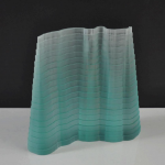
- Brian Thopson, River Wear (2012) float glass, 6.5″x7″x2.5″
-
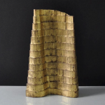
- Sun Gate to Machu Picchu 2012 Gilded Oak, 6ʺ x 4ʺ x 1.5ʺ
-
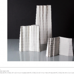
- Porcelain Left to Right: Yudaki Falls (with MC 3.7.2011) ; 6ʺ x 5ʺ x 1.5ʺ Kurobane (with MC 2.7.2011) ; 9ʺ x 4.5ʺ x 1.5ʺ Visit to Mr Hase (with MC 1.7.2011) ; 4ʺ x 6ʺ x 2ʺ
-
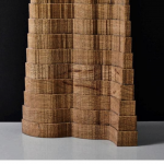
- Brian Thopson, Helvellyn by Striding Edge 2012
-
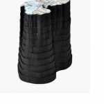
- Brian Thopson, Grasmere Round 2012, wood and print
[credit]
“Brian Thompson has described his work as being “topographical in nature” – concerned with how places become known, understood, named and described. He is interested in the different ways in which we measure, describe and figure the land, and how his experience of walking through a landscape can be re-imagined through sculpture.
He uses a mixture of traditional craft skills allied to new technologies. His works ask us to imagine the formation of landscapes over a long timescale and explores the two- and three-dimensional forms and shapes associated with (amongst other things) walking through a site in order to map it and to unearth its history.
Thompson’s walks, recorded through GPS tracking or tracings from maps and aerial photographs, become the ‘line’ of the walks and the starting point of the sculptures and prints. These ‘lines’ are cut usually by hand and often in wood, with each layer becoming the template for the succeeding layer. Through small increments of size the sculptures evolve, tapering downward from top to base, incorporating errors and corrections; marking layer upon layer, in geological fashion, the history of their making. Sometimes these become ‘patterns’ for fabrication in materials and colors directly relevant to the location or simply have ‘come to mind’ when he makes the walks.
The work seen here combines forms alluding to archaeological and geological understandings of place, and to the imagined objectivity provided by Ordnance Survey mapping. Thompson notes of his three-dimensional works that “the sculptures serve as diaries, records, memories, souvenirs or trophies – celebrations of experiences of particular places”.”