Category Archives: Archiving

Sarah Cullen “The City as Written by the City” 2005-2007

squiggly drawing

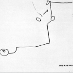
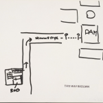
The City as Written by the City, Nov 2 2007, Walk to see Trudi and her new pin, Banff Centre – Banff Hospital

abstract drawing

The City as Written by the City, Out and about Florence with Muma, May 21, 2005

[credit]

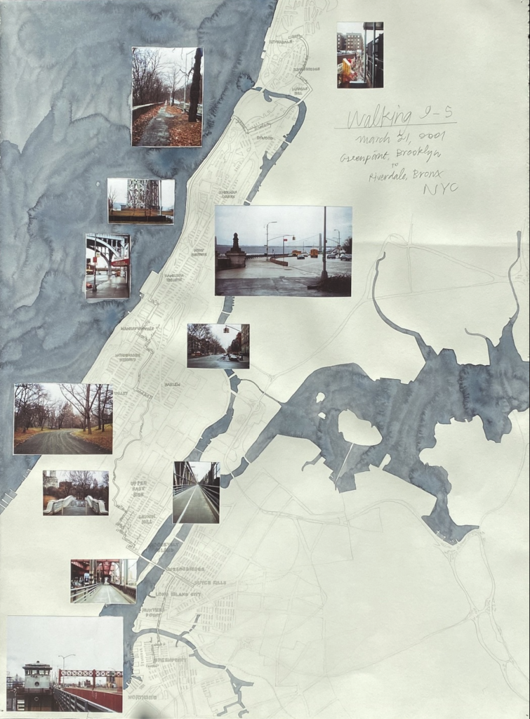
“Sarah Cullen’s recent works have resulted from collaborative activities with geographers and other artists. In the past, she has created alternative methods of mapping space using low-tech machines and devices of her own invention.

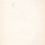
Cullen has, for example, created a ‘drawing box’ consisting of a pencil pendulum that is able to record her movement in space in equivalent strokes of graphite on paper when carried around on a walk. The resulting drawings are almost anti-maps, in the sense that they cannot offer objectivity or legibility. Instead, her artworks bear indexical traces of her presence and motion.

What we lose in immediacy, we gain something in a sense of the weight and measure of movement – of the particular gait and pace of an individual’s walking style. Each of us moves through space with a highly particular and identifiable walk: it is a marker of the way we have learnt to occupy the world. Cullen asks us to re-imagine how we can document the ways in which we have ‘become ourselves’, in motion rather than at rest.”

Photos from constructing the boxes and doing workshops

plan b “All GPS traces in Berlin in 2011-2012” 2012

a map

plan b

two people tracing

plan b

[credit]

plan b is the name that Sophia New and Daniel Belasco Rogers take when working collaboratively as artists. They are amongst the leading figures to engage with GPS technologies since their widespread availability over the last decade or more. Their practice is based on both walking and on data collection including, most notably, their GPS traces. Rogers has tracked every single one of his journeys for a whole decade. New has done the same since 2007. On several occasions they have exhibited an entire year’s worth of traces in one space, effectively making every action they take become public knowledge.

Such actions present ethical problems for us, as much as for the artists. The viewer becomes privy to the artist’s habits and, hence, inner life. If information about apparently innocuous activity such as walking through one’s own city can be timed, monitored and recorded by an artist, such information can easily be known by technology providers and sold to others. Those who might want to observe, redirect, restrict or control our behaviour have new ways of doing so. Most recently, plan b have engraved a whole year’s worth of GPS data onto a transparent acrylic sheet. The journeys that they routinely or repeatedly undertake are ‘dug’ out of the material in an almost archaeological manner. Their habits and ways of inhabiting the city are simultaneously made both monumental and as ghost-like traces.”

Stanley Brouwn, “This Way Brouwn” (1960-64)

A compilation of maps drawn by passersby of directions to a particular location. The artist stamped them all with “This Way Brouwn”.

CURATOR, CHRISTOPHE CHERIX: What’s fascinating here is an artist making a work through his interaction with people. He’s basically delegating the making of his work, not to someone that he chose, but to anyone. And the artist basically gives you here only a starting point and stops right when the work begins.

What he did was to ask someone, “How can I get from here to another point of the city?” And he would hand them a sheet of paper, with a pen or a pencil. And, the passerby was asked to make the drawing. And what Stanley Brouwn did was to ask similar directions to different people. So on one side, you see someone who is telling him with very geometrical line how to cross the city, and someone has a much more smooth, fluid way of crossing the city.” (credit)

Gwen MacGregor, 3 Months New York/ Toronto (2004)

gps mapping

Video still. CREDIT: //www.gwenmacgregor.com/three_months_new_york_toronto.html

GPS Series – 3 months New York / Toronto

VIDEO

single-channel video, duration two minutes, 2004; exhibited: librairie-galerie Histoire de l’oeil, Marseilles, France; Rencontres Internationales Paris–Berlin, Circulo de Bellas Artes, Madrid, Spain; Theatre Babylon, Berlin, Germany, 2007; Transmedia Dundas Square, Year 01 Artist-run Centre, Toronto, 2006

THE FIRST OF THE GPS SERIES, this animation charts my movements for three months in New York and in Toronto. Each day is drawn and then partially fades to allow the day to be seen in the context of the accumulation. By leaving the page white, the identity of the locations are revealed over time. In this way the works uses walking as a creative drawing tool.

ABOUT THE GPS SERIES:
Since 2004 I have been carrying a GPS everywhere I go to record my movements. This raw data is used to create animated drawings for an ongoing series.

[CREDIT]

Danica Phelps, Walking 9-5 Series

drawing of map on folded paper

Graphite on folded paper, 30.625 x 20.5 inches; CREDIT: //www.mutualart.com/Artwork/Walking-9-5–Graz/D328CC010A678FB5

collage on a map

“Walking 9-5, March 21, 2001, Greenpoint, Brooklyn to Riverdale, Bronx, NYC” (2001), Pencil, watercolor and collage on paper, 30 × 22 1/4 in; CREDIT

The earliest work in the exhibition is Walking Amsterdam 9-5 , a sprawling installation of 116 small-sized drawings. Danica created this work in 2002 for the Amsterdam gallery Annet Gelink. She spent three weeks in the city, and 13 days walking through it, for exactly 8 hours every day. Point of departure for these excursions was always the central station, and every one of them proceeded in as straight a line as possible in all directions, 20° off the direction taken the previous day. At 5pm she would look for the nearest means of public transport in order to return to the city centre. One of her 8-hour hikes took her to a suburb of Utrecht, another all the way to Zanfort. The individual drawings on this wall are clustered by days. One lists all the day’s activities, the others represent situations and objects on which Phelps spent money. Every red stripe stands for a Dollar spent, and green stripe for a Dollar earned. The price of each drawing (from 30 to 800 Euros) depends on how much the artist likes the drawing. As she believes that the determination of the price is the final aesthetic decision, the price becomes part of the work itself – and is noted, in US$, on the drawing itself. If a certain drawing finds a buyer, Phelps creates a copy of it on tracing paper, which then replaces the sold drawing in the series. On this ‘second-generation’ drawing she paints a number of green stripes that corresponds to the price fetched by the original, the name of the collector, the gallery and the date of the sale. This in turn renders the copy unique again – and means that it is itself now up for sale. The presentation at Nolan Judin Berlin is the first chance since their exhibition in Amsterdam in 2002 to buy these drawings. [credit]

Millie Chen, Tour (2014)

[credit]

a video showing on the wall of a dark room

Millie Chen, Tour (2014)

Walking across these sites, Chen actively and physically engages with the land to process difficult events. The audio includes lullabies from the countries represented in the work.

Tour, 2014, an audio-video installation that contemplates arguably “healed” genocide sites, provokes the question: How can we sustain the memory of that which has become invisible? How can we possibly represent such horrific history and maintain the critical specificity of the local within a narrative about the global? Events that occurred over the last century retain heat as some victims and perpetrators are still alive, and justice, truth, and reconciliation processes are still underway. Yet, with the passage of this amount of time, these genocidal events are already archived as history—we have gained some distance from them, and have even started forgetting: Murambi, Rwanda (April 16–22, 1994); Choeung Ek, Cambodia (April 17, 1975–January 7, 1979); Treblinka, Poland (July 23, 1942–October 19, 1943); Wounded Knee, United States (December 29, 1890).

A history of human atrocities can become easily absorbed, literally, back into the land. Despite the fact that the violent impact of humans scars the earth, nature can readily absorb these acts of horror, often ironically becoming more verdant as a result. But the brutal facts remain. It is only through the persistence of individuals retelling past events that we can keep alive the history, even as acts of atrocity continue to be perpetrated in the present.

The installations and videos of Millie Chen (Canadian, born Taiwan, 1962) function as sensory experiences that question the perceptual and ideological assumptions of the audience. With her focus on sociopolitical inquiry, Chen explores how art can address the human condition through surrogate cues. About her working practice, Chen states, “Essential to my practice is the role of sensory modes of perception in the generation of knowledge. I have experimented with materiality and with immaterial, non-visual elements like sound and scent within specific contexts in order to interrupt habits of viewing. Within my visual art practice, the act of looking is interrogated.””

Roberley Bell, Still Visible After Gezi (2015)

[credit]

“In 2010, I began photographing the “Istanbul” trees on my daily meanderings through the city streets. These trees were not iconic symbols of the beauty of nature, but rather trees that had negotiated a precarious position within the urban landscape. I returned in 2105, after the Gezi demonstrations to check up on and again photograph my “Istanbul” trees. I returned to try to find the trees, they had become important to me and I knew seeking them out would reveal something –I just wasn’t sure what that would become. I wanted to go back and see, if working from memory, I could relocate these trees. What emerged was a story, theirs and mine, as I moved through the city retracing my footsteps from memory. For me, the trees of Istanbul are a powerful metaphor and stoic symbol of survival speaking to the humanity of the ever-expanding city. The installation Still Visible After Gezi expresses that set of experiences.

For the installation, I conceived each tree as its own story, creating a turquoise frame. Within the frame the tree as I originally photographed it in 2010, smaller images of landmarks that guided me back to the tree in 2015 then finally an image of the tree as I found it five years later or a void. The empty space representing that the tree was no longer there or perhaps I had remembered the location wrong. Still Visible After Gezi includes 16 tree stories.”

Link to Bell’s Site

Michael x. Ryan, Roadstains (2007)

[credit]

a white carved sculpture

Roadstains #3: Coke spill from parked car on Potomac Ave. Chicago, Fall 2004 / Installation in process, view #3, Hand cut wood relief: Finnish and Baltic Birch plywood painted with latex paint to match wall color, 2017

Ryan traced spilled drinks in the street as he went walking. He transferred them to wood carvings painted white.

Mary Mattingly, House and Universe (2013)

[credit]

woman pulling ball of objects

Mary Mattingly, Pull, 2013

“Based on philosopher Gaston Bachelard’s book Poetics of Space with a chapter by the same name, House and Universe describes duality and interdependency within local and nonlocal space. House and Universe is an allegorical series of photographs that combined living systems like floating geodesic capsules with bundles of personal objects I had collected and carried with me. When I was making this work in 2013, I had bundled almost everything in my possession into seven large boulder-like forms that could be rolled or pushed.

One photograph shows a place I lived in between a series of storms when the houses were covered in whatever scrap was available. A bundle sculpture is in front of the homes, symbolically connecting climate disasters with consumption.

That title alludes to the story of Sisyphus (the trickster who was tricked in the end) which stuck with me throughout the series, as I dragged these bundles from one place to another, across towns where I was invited to recreate performances, and back into and out of exhibitions and studio spaces.

Another image shows a naked body of a person in my life from behind, with a large boulder of things provocatively titled Life of Objects.

Own it.us was made at the same time: an online library that catalogs the things I bundled and illustrates the pathways of these objects, and how they came into my life. I’ve spent considerable time living in and within ecosystems or shelters I’ve co-built, some pictured in House and Universe, those experiences have asked me to reconsider my surroundings, to vision how collections can function as monuments to consumption, and how, as an inhabitant of NYC, I help make the collective monument called a landfill.

In absurd performances, I would pull the bundles through NYC, Really to emphasize the weight of these objects.

The sculptures’ wrappings are inextricably intertwined like cycles of production – through a chain of formal and informal exchanges, an object is mined, made, distributed, bought, exchanged, eventually thrown away, where it becomes something else. The photographs of these things echo the cobbled together things themselves: pieced together with images of disparate place, time, and space.  Like time capsules, they function as obstructions and proposals. They block, interfere, and frame an encounter.”

Fallen Fruit, “Public Fruit Maps” (2004-ongoing)

[credit]

Screen Shot of Public Fruit Maps

Screen Shot of Public Fruit Maps

“One of Fallen Fruit’s core projects is to map neighborhoods to which we are invited, mapping all the fruit trees that grow in or over public space. Only pick fruit that is on public space unless you have permission from the property owner. You can find all of our map on the Endless Orchard. If you want to contribute to our online maps- email us! The maps are hand-drawn and distributed free from copyright as jpgs and PDFs. They are regularly reproduced in the media and have been exhibited in museums and gallery exhibitions internationally. The dimensions of the maps are variable and range from 8″ x 10″ to 40″ x 60″. This is an ongoing and ever-expanding project.

NOTE: These maps are for entertainment purposes only. Never trespass or take fruit from private property. Only pick fruit that is clearly in public space- for example hanging over the sidewalk or in the parkway. If you are not sure, ask. Also if you are happy to help us with providing a map, then please make sure that it is your own work. We do not want to deal with someone like this trademark attorney Denver has to offer. Unless you have their permission of course. This is all for a bit of fun and just makes apple picking a lot easier. We look forward to having you onboard!”

photo of feet with fruit in bags and a map

map of fruit trees