Category Archives: Rural

Moira Williams, Fissures, Holes, Limbs: Breathing Dislocated Scales (2019)

person with large had and group walking outdoors

Credit: http://www.moira670.com/#/fissures-holes-limbs/

“Fissures, Holes, Limbs: breathing dislocated scales is an eco somatic sound walk centering disability.

I-Park Kicks off Seventh Art Biennale in East Haddam

BY CATE HEWITT, SEPTEMBER 23, 2019 ART & DESIGN

EAST HADDAM — At night, animals, birds, flowers, and even mushroom spores become active, moving about, making sounds and leaving traces, mostly unbeknownst to humans.

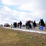
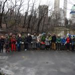
Participants in artist Moira Williams’ sound walk called “Fissures, Holes, Limbs: breathing dislocated scales,” were invited Sunday to shift from “daylight to moonlight” and experience night sounds and images she had recorded onsite at I-Park, an international artist-in-residence program founded in 2001.

Williams, a New-York-City-based artist, is one of nine artists in I-Park’s seventh Site-Responsive Art Biennale who spent three weeks on the program’s 450-acre campus “creating ephemeral artworks that respond to the property’s natural and built environments,” according to the program notes. The artists’ works can “take the form of environmental sculptures, videos, aural experiences or performance pieces.”

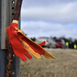
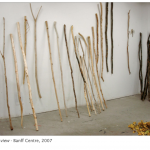
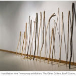
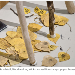
At the beginning of Williams’ sound walk, participants were asked to choose a stick from a number of precut tree branches, mostly about five or six feet in length. These branches were used as “limbs,” extensions of the human body, to explore holes and fissures in the path, as well as rocks and lichen.

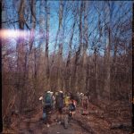
After the band of sound walkers set off along a path, Williams stopped the group at a field and played a recording she had made while camping onsite of an owl hooting.

“Think of how the owl moves so quietly throughout the night and what it disturbs and what it accentuates, think of the different way our breath moves and accentuates as well, think of the spores and the seeds that we never see that we move,” she said.

She asked the group to face the field and to lift up their shoulders and think about them as wings, with the limb as an extension of sorts.

“Think about how they feel in the air and what you can move and what you can share and extend,” she said. “If you have a limb, an extra limb with you, please raise your limb in any way that you like, and think of your shoulders and your extra limb, think of the breeze going through your shoulders and your extra limb.”

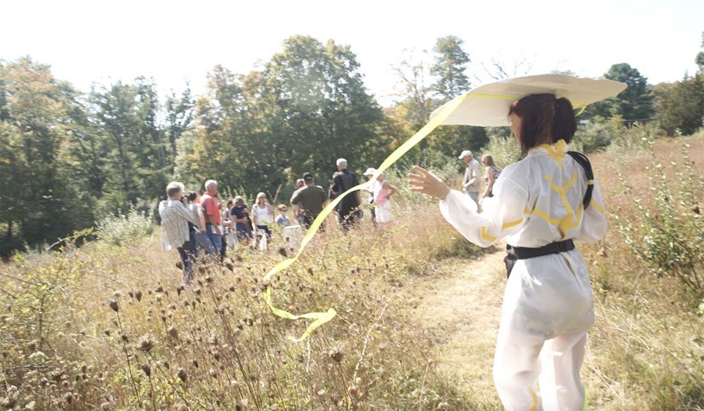
Dressed in a white hazmat-type suit embellished with bright neon stripes made from tape, Williams carried a roll of black wire on one shoulder, like a techie epaulet, and a small speaker and projector connected to her mobile phone in a pouch around her waist. On her head was a wide “hat,” made from a piece of flat white painted cardboard with a space cut out for the top of her head, and long neon green streamers attached at each end that trailed behind her when she walked.

As the group proceeded down the path, Williams removed her hat and projected a tiny video of a fox she had recorded at night, letting the walkers experience the sight and sound as they hiked past.

She asked everyone with “an extra limb” to use it to touch the rocks, holes and lichen along the path, as a way to experience the site.

Soon the group came upon a field where Williams had created a labyrinth.

“Choose a path and walk to where you can find a white stump,” she instructed. “We’re under a full moon in the middle of the night, it’s an extraordinary full moon.”

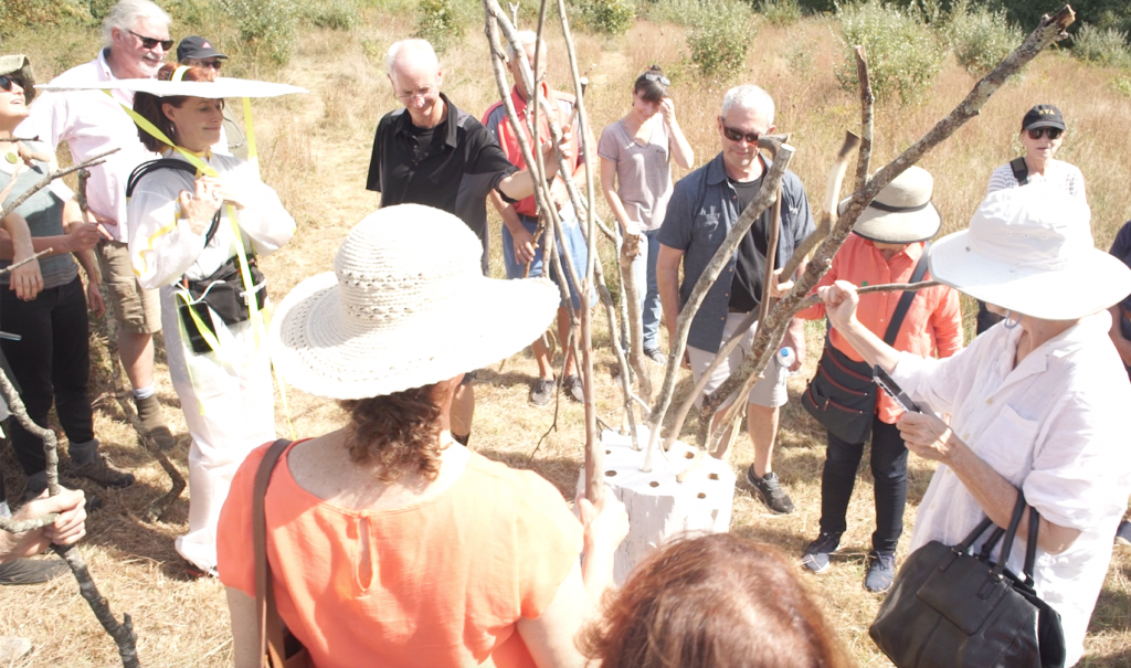
Soon the group gathered around a white stump that had holes drilled in it about the size of the limb walking sticks. She asked those who had limbs to share them with those who were without.

“Those who haven’t had an extra limb, think of the limb that they now have and how the previous person used that limb and what that means to them not to have it now,” she said. “And think about whether the bark is smooth and whether there’s holes or fissures or lichen or even insects on your limb.”

Williams invited everyone holding a limb to place it in one of the holes in the stump, which created a kind of tree sculpture. The new tree symbolized connection, she said, and could forge a new identity for everyone who took part.

people putting sticks in a trunk

Credit: http://www.moira670.com/#/fissures-holes-limbs/

“If you walked with an extra limb and want to think about if you have a new name, you can say your new name out loud if you do have one, or if you can think of a new name that might incorporate an extended limb,” she told the group. “My new name would be Lichen.”

Of the 20 participants, names like Woody, Meadow, Shaggy, Hiawatha and Tripod emerged.

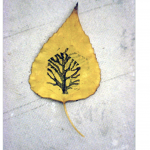
Then Williams directed the walkers’ attention to the far side of the meadow where a large tree with bare branches reached to the sky, a living reflection of the group’s tree made from limbs.

“Look at the tree in front of us and think about the tree behind us and the juncture of all of us connecting all of us,” she said.

Williams next led the group to a boardwalk that snaked through a marshy area with numerous streams flowing along the ground.

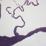
At one point she stepped out of the path and projected a video of mushrooms sporing onto a series of white vertical boards that were set in the marsh.

“This is an image of sporing mushrooms that only spore at night and these are things we seldom get to see,” she said. “They’re just ghostlike spores that we’re gathering on our own bodies and sharing with the rest of the world.”

Williams, who holds a BFA from the School of Visual Arts, a graduate certificate in “Spatial Politics,” and an MFA from Stony Brook University, said her underlying interest is about “making the environment accessible to all people, especially people with disabilities.

“It’s about thinking in ways that are not about independence but more about connectedness with the environment and one another,” she said. “It’s connectedness as a holistic ecosystem, we’re not just this very big myth about how we’re independent.”

She explained that her white outfit reflects a philosophy of healthcare — “the idea of nursing and empathy and being a caregiver.”

“I think of myself as a steward caregiver. I love wearing the white suit because I’m in the lead and I want people to see me,” she said. “The hat is a device to say, hey, here I am, come and join me, but it’s also the width of walkways that need to be for people that need a wheelchair.”

By walking through the marsh and the woods, participants will carry traces of the environment to new places, she said.

Near the end of the path, Williams crouched down, removed her hat and projected a time-lapse video of a lotus flower opening and closing at night on the pond at I-Park, a film she made while floating on the water.

The tour was over and she bade the group good-bye by saying, “Good morning everybody.””

Heath Bunting and Kayle Brandon, D’Fence Cuts (2001)

“Heath Bunting emerged from the 1980s art scene committed to building open, democratic communications systems and social contexts. Throughout his career, he has explored multiple media including graffiti and performance art and has staged numerous interventionist projects, as well as being a pioneer in the field of Internet Art. Bunting began collaborating with artist Kyle Brandon in 2001.” [credit]

These artists devised a circular tour (see map), and by night stealthily cut some fences as part of their Borderxing project. BorderXing serves as a pratical guide to crossing major international borders, legally or illegally. It was a type of physical hacking of space, cutting anything that impeded their walk – D’Fence Cuts. Below is an excerpt from their tour de fence catalog:

“tour de fence is the answer to your real needs. while the internet promised to level out all barriers, tour de fence enables you to surmount the fences out there that people erect to obstruct your way every day. from wire netting to ru­ stic fence, from steel door to close security system, tour de fence offers you the necessary know-how for unhampered movement. tour de fence is the direct way.

learn offroad mobility within high security architecture. cross over stretches of land in the right direction. penetrate the underground area of your city. tour de fence puts an end to the relocation of your movements into virtual space. use the tour de fence! become a tour de fence amateur team. pass this handbook on to others. propagate tour de fence.

by doing so you will become part of the international tour de fence community. as a reader, a free-climber or by sending one of the 24 tour de fence postcard in this book.

participate now! tour de fence’s vision is to do what we want.

tour de fence acknowledges fence as metaphor for private property. fence as a supposedly temporary, often mobile barrier performing functions of inclusion and exclusion, entrapment and guided freedom, decoration, safety, user boun­ dary, protection from hazard, flow control, visual screening and user separation.

fence is a permeable filter system defining permitted use and users. light, wind, insects, water, plants and sound pass unhindered while high order life forms such as·humans, fish, cattle and cars are engaged:

development of fence.

up to now the vertical has generally been private while the horizontal public. increasingly, vertical fences are being rotated to the horizontal and enlarged over large areas of land, as all use and users are embraced in total control.

tour de fence recognises the transformation of framed freedom into restricted open-range roaming; the re-alignment of unknown possibilities into known re­ peatables. users are permitted to skate across flattened surface of fence, but not to pass through – the fence is everywhere.” (credit)

Dakota Commemorative Walk (2002-2012)

“They walked past red barns and white picket fences, past new housing developments and plowed fields dusted with snow. They walked with blisters on their feet and with hats pulled low to ward off the winter wind. They walked to remember.

The sixth annual Dakota Commemorative Walk ends Tuesday, Nov. 13, 2012 after six days retracing the footsteps of the 1,700 Dakota women and children who were forced to march 150 miles to Fort Snelling after the U.S. Dakota War of 1862.

Some call it Minnesota’s Trail of Tears.

“This is a ceremony,” said Gwen Westerman, who teaches humanities at Minnesota State Mankato and who has walked with the group since 2004. “It’s not a protest. It’s not a re-enactment. It’s a spiritual ceremony for healing and for honoring those women and children we descend from. We remember their strength and their determination.”

The first commemorative walk was organized in 2002, and organizers have held one every two years, leading up to this year, the 150th anniversary of the original march. After the Dakota War of 1862, the Dakota men who attacked government offices and white settlements were given cursory trials. Just more than 303 were condemned, and 38 were hanged in Mankato, remembered as a notorious event in Minnesota history.

After the war, 1,700 men, women, children, elders and mixed-race noncombatants were marched to a fenced camp along the river beneath Fort Snelling. During the winter of 1862-63 hundreds died of illness and exposure. In the spring, the remaining 1,300 were taken by steamboat and trains to a semiarid reservation at Crow Creek, S.D., where many more died of starvation and illness.

“They lived through three horrific experiences,” said Chris Mato Nunpa, a retired professor at Southwest Minnesota State University, who was bundled in a black coat and who talked as he walked along the shoulder of the road.

“They lived through this forced march, through the concentration camp, and through the forcible removal from Minnesota.”

He called their ordeal a genocide.

This year’s walkers set out just after dawn Wednesday from the parking lot of the Lower Sioux Agency in Morton, in the Minnesota River Valley. By Monday afternoon, the group had passed through the town of Jordan after covering about 20 miles a day. They walked on the shoulder of Scott County Hwy. 17, followed by a caravan of cars and vans carrying friends, supporters and elders too frail to make the journey on foot. Some people walk all six days; others join for a few days or even a few hours.

Each day, the procession is led by a woman carrying a sacred pipe wrapped in a blanket, surrounded by a quiet group. Farther back, people chat. The walkers stop and place a marker about every mile and honor two ancestors from the march.

At one stop Monday, a woman cleared weeds growing at the base of a tall electrical pole. She pounded a stake into the ground, topped with red and yellow ribbons. Someone called the names on the ribbon into the chilly wind: “Alek Graham. Maline Mumford.”

Then one by one, people went forward, took a pinch of tobacco from a leather pouch and sprinkled it over the stake.

“The name is not just a name. When we call their name, they come,” explained Nick Anderson, cultural chairperson for the Mendota Mdewakanton Dakota Community. “They are here with us.”

He said he walked as a way to thank his ancestors, one of whom was a sister of Chief Little Crow.

“When I think of what they had to endure, I don’t know if we can ever give enough thanks,” he said. “We survived, but we have lost a lot of our culture. Participating in this is a way for me to get some of that back.”

Other people came long distances to walk.

“The reason I’m here is because my great grandmother was on this march with her four kids and her mother,” said Reuben Kitto, who flew in for the march from Florida, where he spent 30 years working for Honeywell. Kitto spent his childhood on the Santee Sioux Reservation in Nebraska where many Minnesota Dakota were sent.

“This walk brings us back to the reality of how hard it was for them,” Kitto said. “The weather was a lot like this, there was a little bit of snow.”

“It’s a way for me to spend a day with my grandmother,” he said.

It’s also a way for him to spend time with his living family. His nephew Robert Thomas drove up from Winona to join the march for a day. Thomas is working on a commissioned play about the Dakota war and exile for the Minnesota History Theater and is concerned with helping both Dakota and non-Dakota remember the Dakota’s past.

“The old aunties and uncles are still passing down the stories,” he said. “The struggle is to get the younger generation interested.”

Kitto’s daughter, Ramona Kitto Stately of Shakopee, also was on the march, bundled in a long red coat and walking next to her father. Stately coordinates Indian education for the Osseo Area Schools and this year, as in past years, brought several students along on the walk.

As the sun started to dip low, she and others arrived at the Shakopee Mdewakanton Sioux Community center, where they would eat dinner together and reflect on that day’s walk.

“We carry a deep grief inside and if we don’t connect with that grief, we can’t heal,” Stately said.” [credit]


Stuart McAdam, Lines Lost (2013-14)

“A project tracing the routes of branch lines that were cut following the Beeching Report in 1963

Stuart McAdam came to Huntly in Summer 2013 from Glasgow.

Stuart’s Lines Lost project was triggered by the infamous railway cuts which saw train tracks closed as a result of Dr Richard Beeching’s recommendations 50 years ago. Through a series of performative walks with all kinds of people along the former Portsoy to Huntly route, McAdam’s aim was to bring into focus the historic and contemporary concerns surrounding our transport legacy.

Through walking the former track again and again, people have seen him reawaken the route that has been subsumed into the landscape – like remains of ghostly traces of the line that once linked communities. Linking natural with industrial and social history of the past 50 years he interrogated the historical, cultural and contemporary resonances through a series of documented walks.

The North of Scotland was one of the areas most affected by the Beeching cuts with local stopping train routes such as Aberdeen – Inverurie, Aberdeen – Keith – Elgin, Huntly to Banff and Portsoy, Banff – Tillynaught, Fraserburgh – St Combs, Elgin – Lossiemouth, Aberdeen – Ballater and Fraserburgh, Maud – Peterhead and Aviemore – Elgin via Inverness, cut. Many of those that crossed the county have never been replaced by other forms of public transport making journeys difficult and adding hours to travel time for those not having access to private cars – passengers have to travel south to Aberdeen or north to Elgin to get connections often having long waits between buses.  McAdam repeatedly walked the route from Huntly to Portsoy, experiencing it through different eyes every time.

“Physical and transparent remnants of most of the lines still exist within the landscape and I hope to reawaken them in the public consciousness”, said McAdam, who has explored journeys, boundaries and slow travel in a range of artworks.

“As we mark the 50th anniversary of the publication of the Beeching report is also fitting time to consider the impact that the cuts had on the relative development and decline of the many towns and villages that lay along the historic routes, routes that were often life lines for outlying communities.”

McAdam was at the Edinburgh Art Festival the 1st of August. For more information go to the event page.

Stuart also participated in the Room to Roam Festival” [credit]

Kinder Mass Trespass (1932)

Kinder Reservoir from Kinder Scout

Kinder Reservoir from Kinder Scout [credit]

In April 1932 over 400 people participated in a mass trespass onto Kinder Scout, a bleak moorland plateau, the highest terrain in the Peak District.

The event was organised by the Manchester branch of the British Workers Sports Federation. They chose to notify the local press in advance, and as a result, Derbyshire Constabulary turned out in force. A smaller group of ramblers from Sheffield set off from Edale and met up with the main party on the Kinder edge path.

Five men from Manchester, including the leader, Benny Rothman, were subsequently jailed.

75 years later the trespass was described as:

the most successful direct action in British history

Lord Roy Hattersley, 2007.

Bowden Bridge Quarry 1932

Bowden Bridge Quarry 1932

“The trespass is widely credited with leading to:

  • legislation in 1949 to establish the National Parks
  • contributing to the development of the Pennine Way and many other long distance footpath
  • securing walkers’ rights over open country and common land in the C.R.O.W. Act of 2000

The trespass was controversial at the time, being seen as a working class struggle for the right to roam versus the rights of the wealthy to have exclusive use of moorlands for grouse shooting. It remains controversial today, both for those reasons and because some think its importance has been overstated. Our aim is to tell the story of the mass trespass, but to put it in the context of all the other contributions made to securing access rights to the moorlands, mountains and countryside of the UK.”

[credit]

Barbara Lounder, Stamp Sticks (2007)

“During a 2007 Walking and Art residency at the Banff Centre, I made walking sticks and related devices, exploring ways in which walking leaves traces and tracks in the landscape. Walking in the Banff area brings a certain frisson; there is always the possibility of dangerous encounters with other species, the elements, and difficult terrain.” [credit]

Dillon de Give, The Coyote Walks (2009-2017)

“An annual walking project that illustrates a connection between New York City and the wild. It was originally performed to commemorate the spirit of “Hal”, a coyote who appeared in Central Park in 2006 and died shortly after being captured and re-released in the forest. The walk begins in the city and remains within sight of a coyote-like path for three days before ending in a relatively wild area. The Coyote Walk has run as an itinerancy, or walking residency since 2014.” [credit]

“It is collaborative research, a retreat (in an almost literal sense), or a mindful holiday. Prospective fellow walkers may share an interest in related subjects, such as urban planning, folk/visual/movement/social arts, biology or other natural sciences. Participants must be prepared for a strenuous walk (approx. 15 miles per day) and for sleeping outside. Please note, differently abled walkers are encouraged to be in touch.” [credit]

Additional images and writing www.coyotewalks.wordpress.com

“I grew up in the Southwest US (Santa Fe, NM— where coyotes are ever-present both as biological entities and as cultural signifiers). I witnessed this event in the media while living in New York City, and continued to think about it in the years following. I began to feel that a larger narrative was looming behind the topical debates. The incident threw the relationship of the city dweller and the natural world into relief.  It wasnʼt an abstract suggestion of interconnection between the two; it was a (momentary) unmediated instance of collision– a moment of confusion for both. Hal disrupted a normal state of affairs by presenting himself as an embodiment of something external to our picture of daily life in an orderly civilization. In this he was as comedic as he was threatening. Was this a typical animal or an exceptional one? What was he thinking? And how, exactly, did he find his way into the city?

One way to try to understand this story was to guess about the geography of the journey.  The most obvious geographic challenge is the channel of water that separates the island of Manhattan from the mainland of the Bronx– like a moat surrounding a castle. Adrian Benepe, the NYC Parks Commissioner at the time, publicly hypothesized that Hal crossed a small Amtrack trestle bridge over the Spuyten Duyvil Creek at the northern tip of the Manhattan. This became a prevailing theory, but not the only possible one. Other scenarios were equally possible. For example, if Hal had utilized the long Bronx River corridor as a path, he might have crossed over the Harlem River further south and east. Because there were few eyewitness accounts, no camera traps, and no DNA analysis done on Hal, the definite crossing location will remain unknown. This crossing is a big plot point of the story as presented in the media. It came to stand for the dramatic moment in which a cunning trickster privately transgressed from the natural world into the human world. Looking closely at possible routes however, it becomes clear that there were many such crossings.

The Coyote Walks are fueled by curiosity about what it would mean to cross over the line between “the city” and “nature” oneself, to literally connect the two places. The walks are guesses about how coyotes enter New York City that are made with reverse human journeys out of the city. The project began as a kind of memorial to the incident— walked around the anniversary of Hal’s death and initially called the “laH” journey, a backwards spelling of the name. The Coyote Walk is now a time to pose questions about urban life and nature, to learn from the experience of stepping away from the city, and to consider walking practices (human and animal) as imaginative acts.” [credit]

Artist writing:

  • Unpacking (after) a coyote walk. Walking Lab residency, 2017. Link.

  • Connective filaments, coyote walks on the map. Living Maps Review No. 2, 2017.
    Link / Download PDF

  • Tracking the call of the wild from the heart of Manhattan. NYNJ Trailwalker Summer 2012. Download PDF

Speaking:

  • Artists and the Post Industrial Urban Wilderness, Union Docs, 2017. Link

  • Chance Ecologies Symposium, Queens Museum, 2016. Link

  • Re-inscribing the City: Unitary Urbanism Today, Anarchist Book Fair, 2011. Link

Referenced:

  • Urban Coyotes Spur Walks on the wild side. CUNY NYCity News Service. Audio piece by Samia Bouzid

  • “‘Uurga shig’ – What is it like to be a lasso?” Hermione Spriggs, Journal of Material Culture, 2016. Link

  • Out Walking the Dog blog, Melissa Cooper 2011-12. Link

  • City Reliquary event write up in Matt Levy’s Action Direction blog, 2009. Link

Mother Earth Water Walk (2003-2017)

[credit]

“Two Anishinawbe Grandmothers, and a group of Anishinawbe Women and Men have taken action regarding the water issue by walking the perimeter of the Great Lakes.

Along with a group of Anishinabe-que and supports, they walked around Lake Superior in Spring 2003, around Lake Michigan in 2004, Lake Huron in 2005, Lake Ontario in 2006 and Lake Erie in 2007.

The 1st Annual Women’s Water Walk took place April 2003. Several women from different clans came together to raise awareness that our clean and clear water is being polluted by chemicals, vehicle emissions, motor boats, sewage disposal, agricultural pollution, leaking landfill sites, and residential usage is taking a toll on our water quality. Water is precious and sacred…it is one of the basic elements needed for all life to exist.

The Annual Women’s Water Walk was chosen for Spring because for the natural re-growth of our natural habitat, as it is a in time for renewal, re-growth, and re-birth.

A team of 6 – 8 Aboriginal people volunteer to walk and help with the everyday necessities such as having multitasked drivers to accompany walkers, food preparation, refreshment breaks, camp set ups, cleaners, laundry etc.

Public Relations Personnel have been involved throughout by taking shifts, and also going ahead to communities to aid with the awareness of the walk. This includes the distribution of media releases, posters, pamphlets, advertisements, and meeting and greeting of the participating walkers.

The overall result after implementation is to gather other groups and/or organizations to participate in an all regional walk around the Great Lakes. The goal is achieved strength in numbers with other Aboriginal men/women in the Great Lake Regions. The anticipated outcome is to have all people aware of the importance of the water and gain support and the gathering of other supporters whom would share an interest in protecting our water through our walk. This event will be annually, with the intent of the Women’s Water Walk to gain awareness and support for annual walks throughout the region. This will entail support, recognition, and awareness of the importance of keeping Great Lake waters clean.

It is anticipated that eventually challenges with other organizations to come together each spring to adopt a common like to care and protect from further pollution.

Stakeholder participation presently resides within the Biidaajiwun Local. Biidaajiwun Local is a women’s group run exclusively by women to raise awareness of issues, pertaining the needs of Aboriginal women. Contribution factors involve the housing of public relation workers, volunteers, support and the participation of several women sharing in the protection of our waters.

It is the hope that other locals, individuals and organizations will come together annually to spread interest and awareness in their communities. This annual event is intended to gain support to raise awareness throughout the region.

The originality of this idea is uncommon as there are few who are ready and willing to take on such a challenge. This idea is original because of how society today is taught to rely on the technological equipment, and that the mere thought of a walk being more than 15 minutes is a task for many. We strive our own determination that this challenge is seldom being done elsewhere, particularly in our region. We are doing this walk on our own beliefs within our own aboriginal culture and values of the importance of our waters is very precious and sacred to our being, as it is one of the basic elements needed for all life to exist.

In doing so, we know that such an endeavors requires a certain amount of funds to help carry the walk over for a two month period, but this alone will not prevent us from carry out what our grandfathers have predicted. Our waters will be scarce and will be deficient in the essential means for our survival….our water.”

Lisa Myers, and from then on we lived on blueberries for about a week (2013)


Lisa Myers, ‘and from then on we lived on blueberries for about a week’, made for MAP Spring 2013, 6’44” (animation with assistance from animator Rafaela Kino). This work pays homage to an on-foot journey her grandfather undertook to flee Shingwauk Residential School in Ontario. Myers herself once did an 11-day walk tracing the route of her grandfather’s journey.

“When he was a boy, artist Lisa Myers’s Anishinaabe grandfather walked some 250 kilometres along Northern Ontario railroad tracks for one reason: to escape Shingwauk Residential School in Sault Ste. Marie.

Myers recorded her grandfather’s account of this journey during a conversation with him in the 1990s—and she listened it to it many times before she made the decision, in 2009, to walk the route he’d described alongside her cousin Shelley Essaunce and her nephew Gabriel.

Myers and the Essaunces took 11 days to walk the 250-kilometre journey.

“After this walk,” Myers writes in a 2016 Walter Phillips Gallery exhibition essay titled “Rails and Ties,” “I began thinking about how to locate myself within my grandfather’s story, and about how I wanted to convey its different iterations. One thing that struck me was that he survived by eating blueberries growing along the tracks. He said, ‘and from then on we lived on blueberries for about a week.’”

The latter quotation from her grandfather became the title for a video installation by Myers—one related to trauma, food, walking and survival—that was on view at Artcite in Windsor this spring as part of the exhibition “Walks of Survivance.”

“Instead of always repeating his story, [walking] was a way of finding myself in that story,” Myers told curator Maya Wilson-Sanchez a few years ago. And by walking, Myers also told Wilson-Sanchez, she was “able to bring the places in the story to life.”

“When I recall walking across the railway bridge over the Mississauga River north of Lake Huron,” Myers writes in “Rails and Ties,” “I think about my fear of the elevation, and how gusts of wind unsteadied my steps. Finding my footing meant looking down and seeing the river rushing 50 feet below the railway ties of that century-old steel bridge. The Mississagi River flows into Lake Huron, the railway crosses the river, and from my grandfather’s account of his journey this was the first place (after leaving school) where he heard his language and saw Anishinaabe people cooking and sharing food down by the river. They welcomed him, and fed him.”

During her walk in her grandfather’s footsteps, Myers also heard stories of other youth who had escaped the way he had. Ultimately, her works on this theme—which include both abstract and map-like prints made with blueberry pigments, as well as documentation of wooden spoons stained with blueberries she has shared with others, also speak to a complex intertwining of group and individual journeys, of landscapes that are real and imagined.

“The spoons represent sharing, sustenance and the gathering of people,” Myers writes. “When I line these spoons up side by side, the reddish-blue marks continue from one utensil to the next, recalling an imaginary topography or horizon line created by the trace of berry consumption.”

In this sense, walking and artmaking become different ways of tracing and “straining” an experience.

“Straining to survive, or even to be accepted, means the less digestible parts of stories need to be retained, traced, remembered and told,” Myers writes.

Of course, Myers is not alone in thinking about walking as a mode of Indigenous resistance and survival.

“There’s the water walk that is happening, and which is not directly art-related,” Myers said in a phone interview. “But I think Indigenous artists are wanting to also acknowledge that these forms of activism are happening. There was walking from a community in Nunavut, [Idle No More] walking to Ottawa to make a point.”

“Walking to safety is a really important narrative in talking about survival, and surpassing survival to freedom,” says “Walks of Survivance” curator Srimoyee Mitra.” [credit]


Lisa Myers, ‘Blueberry Spoons’, 2010, video, 7’37”

Máiréad and Tim Robinson, Folding Landscapes (1972-)

a map

Tim Robinson “Oilerin Arann a map of the aran islands Co. Galway eire” (1996)

“Tim Robinson [1935-2020] is the alter ego of artist Timothy Drever whose abstract paintings and environmental installations were seen in a number of exhibitions in London before he moved to the west of Ireland in 1972. Robinson originally studied mathematics at Cambridge and worked as a teacher and artist in Istanbul, Vienna and London.

He and his wife, Máiréad [1934-2020], [then lived] in Roundstone in Connemara, where, in 1984, they established Folding Landscapes, a specialist publishing house and information resource center dealing with three areas of particular interest around Galway Bay: the Aran Islands, the Burren and Connemara. The maps and accompanying books are beautifully drawn and meticulously researched, explaining, often for the first time, the derivation and meaning of hundreds of place names and representing a wide range of information about the region’s culture and landscapes.

[They] gained much of this information literally on the ground, walking with naturalists, historians, archaeologists and other specialist through the landscape. [Their] maps and books provide an invaluable guide for visitors to the region as well as nourishing community spirit by identifying the irreplaceable uniqueness of the local environment and history. Tim and Mairead also run Unfolding Ideas, an annual Colloquium Series for scholars, educators and artists to engage in public talks, small group discussion and workshops in Roundstone, Connemara.”