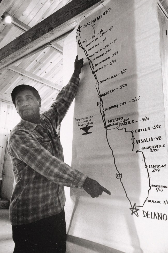
Category Archives: Rural

Menhirs

menhir

Large menhir located between Millstreet and Ballinagree, County Cork, Ireland

Walking as an artistic practice has a long history. Scholars such as Francesco Careri trace this history back to early nomads and wanders. Careri calls out large stone markers called menhirs, erected in the Neolithic landscape throughout Egypt, Ancient Greece, and Western Europe. The menhirs have widely debated possible purposes connected to walking, such as “sacred paths, initiations, processions, games, contests, dances, theatrical and musical performances.” Careri specifically calls out menhirs as early architectural objects used by nomadic hunters and shepherds – people who relied heavily on walking. Art historians can spot material and scale-related connections between these rocky menhirs and Land Art walking practices of the 20th century.


SOURCE: Careri, Francesco. Walkscapes: Walking as an Aesthetic Practice. Culicidae Architectural Press: 2017.

Cecilia Ramón, Free Range Trials (2018)

(credit)

paths in the grass

Cecilia Ramon, Free Range Trials

Cecilia Ramon’s drawings, projection and earthwork, focus on ocean currents, water movements and aquatic organisms. Oceangrass, an earthworks installation piece, is a walk to experience the planetary path of the Thermohaline Ocean Global Current.

James Bay Cree youth, The Journey of Nishiyuu (2013)

[credit]

Six youths and a guide left Whapmagoostui in January to snowshoe and walk to Ottawa in support of the Idle No More movement. They called the trek “The Journey of Nishiyuu,” which means “The Journey of the People” in Cree.

The group numbered nearly 400 in the trek’s final hours, according to volunteers and Gatineau police, after other children and youth from Cree and Algonquin communities joined them along the way. Thousands more people joined them on Monday afternoon at Parliament Hill as their journey came to an end.

The group’s wish to meet with the prime minister was not met, as Stephen Harper was in Toronto Monday for a special ceremony to greet two Chinese pandas en route to the Toronto Zoo.

But Aboriginal Affairs Minister Bernard Valcourt did meet with a small group of the original walkers late in the day. No cameras were allowed at the meeting, but the minister was said to have accepted an invitation to visit their First Nation this summer and learn more about their concerns.

7 walkers began journey

David Kawapit, 18, is one of the original seven walkers who set out from Whapmagoostui.

“It feels really good, but at the same time I’m really sad that it’s ending,” he said on Sunday as the group reached Chelsea, Que., about a three-hour walk from Ottawa. “Because a lot of us shared a lot good times here, sad times, but we all stuck together.”

Others on the walk have told Kawapit it’s helping them deal with personal struggles, Kawapit said, including depression and suicidal thoughts. Kawapit struggles with the same.

“It feels really good that a lot of people are paying attention to what’s going on, and that a lot of these guys that are walking with us are helping themselves on this journey.

“But this journey’s really shown me a lot — how much I can help people. And it’s really given me a better understanding of life. I’ve made a lot of friends here, so there’s no way I’m going to leave them.”

“An Indigenous-led Social Movement

Idle No More started in November 2012, among Treaty People in Manitoba, Saskatchewan, and Alberta protesting the Canadian government’s dismantling of environmental protection laws, endangering First Nations who live on the land. Born out of face-to-face organizing and popular education, but fluent in social media and new technologies, Idle No More has connected the most remote reserves to each other, to urbanized Indigenous people, and to the non-Indigenous population.

Led by women, and with a call for refounded nation-to-nation relations based on mutual respect, Idle No More rapidly grew into an inclusive, continent-wide network of urban and rural Indigenous working hand in hand with non-Indigenous allies to build a movement for Indigenous rights and the protection of land, water, and sky.” [credit]

Cesar Chavez, March for Justice (1966)

[credit]

Cesar Chavez in front of map

Cesar Chavez

“In the spring of 1966, a small group of California farmworkers and their supporters captured the attention of the nation.

On the morning of March 17, 1966, nearly a hundred striking farmworkers, most of them Mexican American and Filipino, set out on foot from the small town of Delano, bound for the state capital in Sacramento 280 miles to the north. As they passed through the dusty highways and farming communities of the Central Valley, they were joined by student activists, union organizers, civil rights workers, and members of the clergy, all drawn to the remote regions of California in support of the farmworker struggle.

For six months, the farmworkers had been on strike. They refused to harvest grapes in the vineyards around Delano until the growers met their demands for higher pay, safer working conditions, and recognition of their unions, the National Farm Workers Association (NFWA) and the Agricultural Workers Organizing Committee (AWOC).

But farmworkers were at a severe disadvantage in their efforts to negotiate the terms of their employment. They lacked the basic labor protections guaranteed to other American workers, including the right to union representation and equal treatment under the law. Whereas other workers could appeal to the federal government if their employers refused to bargain with their unions, farmworkers had no legal basis for making their demands. Instead, they took their pleas for justice directly to the American public.

From March 17 to April 10, 1966, the farmworkers and their growing number of supporters marched to shine a light on the conditions in the fields, exerting pressure on growers and government officials to finally take action. By the time the march concluded in Sacramento, the NFWA had won its first union contract, a landmark victory for the farmworkers and the beginning of what was not only a labor movement, but a cause—la causa—demanding for farmworkers the fundamental rights and freedoms to which other American workers were entitled.

The 1966 farmworker march was not only a part of the farmworkers’ struggle for justice; it was a key moment in the civil rights struggles of the 1960s. The farmworkers who marched from Delano to Sacramento represented the large, seasonal labor force, composed overwhelmingly of people of color, whose labor made California’s thriving agricultural industry possible. Although their labor produced fortunes from the soil, they were subjected to poor wages and working conditions. Farmworkers also experienced legal and illegal discrimination. In the farmworker movement, like the broader Civil Rights Movement, economic inequality and social injustice went hand in hand. By forging a unique coalition of labor, civil rights, and religious leaders, farmworkers successfully overcame the entrenched power structures of California agriculture. Their movement challenged some of the most powerful people and corporations in the state, demonstrating a remarkable resilience and ingenuity on the path from Delano to Sacramento.”

Samuel Rowlett, Landscape Painting in the Expanded Field (2012)

Millie Chen, Tour (2014)

[credit]

a video showing on the wall of a dark room

Millie Chen, Tour (2014)

Walking across these sites, Chen actively and physically engages with the land to process difficult events. The audio includes lullabies from the countries represented in the work.

Tour, 2014, an audio-video installation that contemplates arguably “healed” genocide sites, provokes the question: How can we sustain the memory of that which has become invisible? How can we possibly represent such horrific history and maintain the critical specificity of the local within a narrative about the global? Events that occurred over the last century retain heat as some victims and perpetrators are still alive, and justice, truth, and reconciliation processes are still underway. Yet, with the passage of this amount of time, these genocidal events are already archived as history—we have gained some distance from them, and have even started forgetting: Murambi, Rwanda (April 16–22, 1994); Choeung Ek, Cambodia (April 17, 1975–January 7, 1979); Treblinka, Poland (July 23, 1942–October 19, 1943); Wounded Knee, United States (December 29, 1890).

A history of human atrocities can become easily absorbed, literally, back into the land. Despite the fact that the violent impact of humans scars the earth, nature can readily absorb these acts of horror, often ironically becoming more verdant as a result. But the brutal facts remain. It is only through the persistence of individuals retelling past events that we can keep alive the history, even as acts of atrocity continue to be perpetrated in the present.

The installations and videos of Millie Chen (Canadian, born Taiwan, 1962) function as sensory experiences that question the perceptual and ideological assumptions of the audience. With her focus on sociopolitical inquiry, Chen explores how art can address the human condition through surrogate cues. About her working practice, Chen states, “Essential to my practice is the role of sensory modes of perception in the generation of knowledge. I have experimented with materiality and with immaterial, non-visual elements like sound and scent within specific contexts in order to interrupt habits of viewing. Within my visual art practice, the act of looking is interrogated.””

Nevin Aladag, Session (2013)

[credit]

“Session is a video triptych shot in Sharjah’s urban areas and desert. In this musical composition, different kinds of Arabic, African and Indian percussion instruments, all found in the United Arab Emirates, are played by the elements – the sand, the sea and the wind.”

From Wanderlust catalog: “Aladag’s work explores the textures of socio-spatial environments and global cultural identity. In Sessions we are thus invited to become not only viewers and listeners, but also voyagers and cartographers, navigating the enigmatic edges of our surrounding environments through surfaces and socially activated gestures.”

Nasca Culture, “Pampas de Jumana” (200 BCE – 500 CE)

drawing of a spider in the earth

CC BY-SA 4.0
File:Líneas de Nazca, Nazca, Perú, 2015

[credit]

“The lines are found in a region of Peru just over 200 miles southeast of Lima, near the modern town of Nasca. In total, there are over 800 straight lines, 300 geometric figures and 70 animal and plant designs, also called biomorphs. Some of the straight lines run up to 30 miles, while the biomorphs range from 50 to 1200 feet in length (as large as the Empire State Building).”

What Are the Lines?

The lines are known as geoglyphs – drawings on the ground made by removing rocks and earth to create a “negative” image. The rocks which cover the desert have oxidized and weathered to a deep rust color, and when the top 12-15 inches of rock is removed, a light-colored, high contrasting sand is exposed. Because there’s so little rain, wind and erosion, the exposed designs have stayed largely intact for 500 to 2000 years.

Scientists believe that the majority of lines were made by the Nasca people, who flourished from around A.D. 1 to 700.

Certain areas of the pampa look like a well-used chalk board, with lines overlapping other lines, and designs cut through with straight lines of both ancient and more modern origin.

The Theories

The Kosok-Reiche astronomy theories held true until the 1970s when a group of American researchers arrived in Peru to study the glyphs. This new wave of research started to poke holes in the archeo-astronomy view of the lines (not to mention the radical theories in the ‘60s relating to aliens and ancient astronauts).

Johan Reinhard, a National Geographic Explorer-in-Residence, brought a multidisciplinary approach to the analysis of the lines: “Look at the large ecological system, what’s around Nasca, where were the Nasca people located.” In a region that receives only about 20 minutes of rain per year, water was clearly an important factor.

“It seems likely that most of the lines did not point at anything on the geographical or celestial horizon, but rather led to places where rituals were performed to obtain water and fertility of crops,” wrote Reinhard in his book The Nasca Lines: A New Perspective on their Origin and Meanings.

Anthony Aveni, a former National Geographic grantee, agrees, “Our discoveries clearly showed that the straight lines and trapezoids are related to water … but not used to find water, but rather used in connection with rituals.”

“The trapezoids are big wide spaces where people can come in and out,” says Aveni. “The rituals were likely involved with the ancient need to propitiate or pay a debt to the gods…probably to plead for water.”

Reinhard points out that spiral designs and themes have also been found at other ancient Peruvian sites. Animal symbolism is common throughout the Andes and are found in the biomorphs drawn upon the Nasca plain: spiders are believed to be a sign of rain, hummingbirds are associated with fertility, and monkeys are found in the Amazon—an area with an abundance of water.

“No single evaluation proves a theory about the lines, but the combination of archeology, ethnohistory, and anthropology builds a solid case,” says Reinhard. Add new technological research to the mix, and there’s no doubt that the world’s understanding of the Nasca lines will continue to evolve.

Robert Smithson, “Spiral Jetty” (1970)

[credit]

spiral rock pile

Robert Smithson’s earthwork Spiral Jetty (1970) is located at Rozel Point peninsula on the northeastern shore of Great Salt Lake. Using over six thousand tons of black basalt rocks and earth from the site, Smithson formed a coil 1,500 feet long and 15 feet wide that winds counterclockwise off the shore into the water.

“Robert Smithson’s earthwork Spiral Jetty (1970) is located at Rozel Point peninsula on the northeastern shore of Great Salt Lake. Using over six thousand tons of black basalt rocks and earth from the site, Smithson formed a coil 1,500 feet long and 15 feet wide that winds counterclockwise off the shore into the water.”

Bruce Nauman, “Untitled” (1998-1999)

[credit]

Bruce Nauman Oliver Ranch Steps

Bruce Nauman Oliver Ranch Steps

“Nauman’s staircase sculpture at Oliver Ranch is a response to the physical contours of the land it crosses. Though all the treads are exactly the same size, 30 inches square, every riser is different and measures the land’s changing contours every 30 inches for the length of the staircase, almost a 1/4 of a mile. The smallest step is 3/8 of an inch; the largest step is 17 inches. In classic Nauman fashion, about the time you want to look at the view, you need to focus on your feet or you may fall because of the changes in step height.”